Bigbury-on-Sea, Arymer Cove & Burgh Island
Devon Walk
County/Area - Devon
Author - Lou Johnson
Length - 5.0 miles / 8.1 km Ascent - 800 feet / 242 metres
Time - 3 hours 20 minutes Grade - easy/mod
Maps 

| Ordnance Survey Explorer OL20 | Sheet Map | 1:25k | BUY |
| Anquet OS Explorer OL20 | Digital Map | 1:25k | BUY |
Walk Route Description
Click image to see photo description.
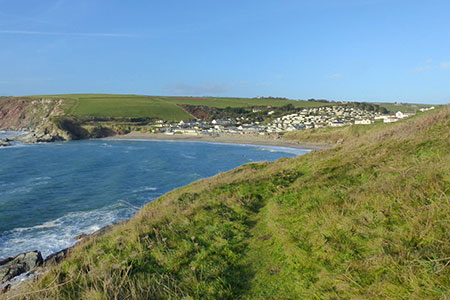
A pleasant South Devon walk from Bigbury-on-Sea that visits the pretty village of Ringmore before joining the South West Coast Path at Toby's Point. The route then follows a scenic section of the coast path to Challabrough before passing Warren Point on the way back to Bigbury-on-Sea. Depending on tides a circuit of Burgh Island can either be completed by walking across the beach or using the sea tractor at high tide.
The start is the large pay and display car park (grid ref. SX651442) at the end of the B3392 opposite Burgh Island. After parking exit the car park and turn right along the B3392 with the sea on your right. In a short distance leave the road and follow the South West Coast Path around Sharpland Point. The path re-joins the road. Cross the road and continue along the South West Coast Path which runs parallel to the B3392. Continue up the rising path to reach Mount Folly Farm on your right (grid ref. SX661446).
At a T-junction opposite the farm, turn left along a clear track leaving the South West Coast Path. Where the track bends left, continue ahead, and maintain direction across several fields to reach another track. Cross the track and continue ahead to a lane (grid ref. SX656453). Go straight across the lane on a clear path descending to a footbridge. Maintain direction uphill passing a house on your left to join a track which leads uphill into Ringmore village. Reaching a road, bear left and pass between whitewashed cottages to a junction with the church opposite (grid ref. SX653460).
Turn left at the junction and keep straight ahead at the first junction to pass the Journey's End Inn on your right. Bear left up hill where the lane forks (opposite the pub) and at the next junction turn right (signed to Aymer Cove). Follow the lane for a short distance and fork left onto a signed bridleway and continue down to the South West Coast path at the cove and St. Toby's Point.
Turn left along the coast path initially heading uphill before descending to Challabrough Bay Holiday Park. You briefly join a tarmac lane before the coast path resumes. A short optional diversion to the right leads to Warren Point. Continue along the coast path back to Bigbury-on-Sea. To complete the walk cross the beach (or use the sea tractor at high tide) to Burgh Island with the world-famous Art Deco Hotel dominating the island. A circuit of the island can be completed using the network of paths on the island before returning across the sands to the start.
Other walks nearby
| Walk 3041 | Thurlestone circular | easy | 4.0 miles |
| Walk 2461 | Warren Point & Bolt Tail from Bantham | moderate | 9.0 miles |
| Walk 3432 | Salcombe to Thurlestone | mod/hard | 11.0 miles |
| Walk 3276 | Gara Point & Stoke Point from Noss Mayo | easy/mod | 7.0 miles |
| Walk 2012 | Wembury Bay & St Peter's Church from Noss Mayo | easy/mod | 6.0 miles |
| Walk 1866 | East Prawle & Prawle Point | easy/mod | 4.1 miles |
| Walk 2474 | East Prawle Coast Circular | easy/mod | 5.6 miles |
| Walk 3387 | Upper Erme Valley & Ugborough Moor | moderate | 9.3 miles |
| Walk 3431 | Beeson to Salcombe | mod/hard | 12.0 miles |
| Walk 2018 | Saltram Park & Hardwick Wood, Plymouth | easy | 5.0 miles |
Recommended Books & eBooks
No suggestions for this area.Messaging & Social Media
Message Walking Britain and follow the latest news.

Mountain Weather
Stay safe on the mountains with detailed weather forecasts - for iOS devices or for Android devices.