Table Mountain from Crickhowell Walk
Walk 3717 - Route Maps & Profile
Route Map
Digital Maps - Copyright © 2011-2024. All rights reserved.
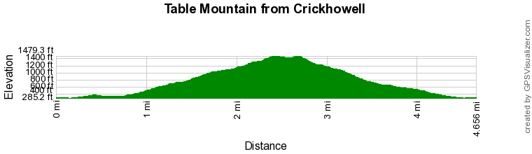
Route Profile
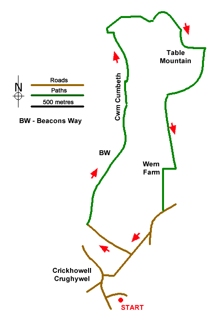
Sketch Map
Suggested Maps 

| Ordnance Survey Explorer OL13 | Sheet Map | 1:25k | BUY |
| Anquet OS Explorer OL13 | Digital Map | 1:25k | BUY |
It is recommended you take a map. The preferred scale is 1:25k.
Start Point Details
Ordnance Survey Grid Ref SO219184
Latitude 51.858699 Longitude -3.135468
Postcode NP8 1BP
what3words start burden.bandaged.wishing
Walk description may contain detailed information on the start point for this walk.
Further Information
Brecon Beacons
Walking in the Brecon Beacons National Park (Bannau Brycheiniog) covers a wide area in South Wales. The high summits of the Beacons themselves tell only part the story as, like most National Parks, there is a varied range of scenery to be enjoyed within its boundaries. Brecon Beacons Walking Guide
Powys
Powys is a large county in east and central Wales, bordering England. The county features a rugged landscape of valleys and mountains, including most of Brecon Beacons National Park. The valley lowlands contrast with the highlands which include the Radnor Forest, the Black and Berwyn mountains, and the Brecon Beacons. The Offa's Dyke long distance path crosses the county on the eastern border with England. The county offers a wide range of walking from gentle valley paths to adventurous mountain walks.
Walk grading - Learn how each walk is assessed and select a walk to suit your ability and experience by going to Walk Grading Details.
Messaging & Social Media
Message Walking Britain and follow the latest news.

Mountain Weather
Stay safe on the mountains with detailed weather forecasts - for iOS devices or for Android devices.