Brimham Rocks Circular
Nidderdale AONB Walk
Region - Nidderdale AONB
County/Area - North Yorkshire - Nidderdale AONB
Author - Lou Johnson
Length - 4.7 miles / 7.6 km Ascent - 350 feet / 106 metres
Time - 2 hours 40 minutes Grade - easy
Maps 

| Ordnance Survey Explorer 298 | Sheet Map | 1:25k | BUY |
| Anquet OS Explorer 298 | Digital Map | 1:25k | BUY |
Walk Route Description
Click image to see photo description.
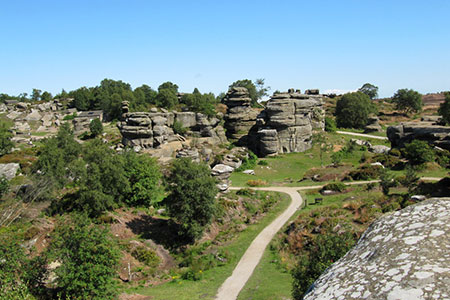
This circular walk explores Brimham Rocks which is an outcrop of Millstone Grit known for its eroded rocks. Situated in the Nidderdale AONB, the area, managed by the National Trust (NT), has been a Site of Special Scientific Interest since 1958. This walk initially follows a short waymarked route around the highlights before continuing to explore the area by following paths around the boundary.
The start is the National Trust pay and display car park (grid ref. SE208646). To start, leave the car park and follow the blue way markers around the Circular Walk in a clockwise direction. This walk will introduce you to some of the wonderful rock formations including The Eagle, the Dancing Bear, and the Idol. Complete the circuit and return to the car park. (Please note the GPS file does not include this part of the walk.)
The second part of the exploration follows the Boundary walk in an anti-clockwise direction. From the car park walk down the entrance road and just before the public road across the moor, turn right down a track (signed Druid Caves Farm). Continue to just before the NT boundary and turn left, then fork right (with wall on your right). Continue for 300 metres down to a gate on your left and turn left to reach the road (grid ref. SE208640).
Cross the road and take the path to the left of a large rock. After 100 metres the path forks. Continue ahead ignoring the left-hand fork. Continue for about 600 metres to a path junction with a fingerpost. Turn right along the Nidderdale Way. Walk through a small copse and continue towards a gate, a stile, and the NT boundary sign (grid ref. SE218643). Just before the gate cross the stile on the left and head slight left downhill to a wall and small copse. Bear left.on the path and cross a small footbridge. The path soon bears left. Take the path over a gulley using the boarded bridge. Follow the path as is bends sharp right and rises onto the moor. Brimham Rocks lie ahead, and after 400 metres you reach the road (SE214650).
Turn sharp right along a concrete track (marked private). After 200 metres turn left on a path to cross a small bridge. Continue along this path to reach the road. Turn right and continue along the road for 500 metres. Where the road turns sharp right, take the track on your left (signed Private Road and Public Footpath). Continue on this farm track for nearly 800 metres to a stile on your left, just before the gate into farm (grid ref. SE206654).
Cross the stile to reach the junction of three paths. Take the middle path ignoring the paths by the right hand and left-hand walls. The path climbs gently to a wood. Follow the meandering, rising path through the trees to exit into the rocks Brimham. Reaching the main path, turn right. You will pass close to the Idol and the Druid's Writing Desk. Stay on the path which runs behind the visitor centre on your left to reach a road from the VC. Follow the road as it bends sharp left. Reaching a stone gulley across the road, turn right onto a grassy path heading downhill (grid ref. SE206650). After 100 metres, turn right by some small rocks to reach a path junction with three paths leading downhill. Take the middle path to join a farm track. Turn left along the track which leads back to the road from where you can return to your car.
Other walks nearby
| Walk 3507 | Dacre Banks Circular | easy/mod | 6.5 miles |
| Walk 2405 | Ripon Rowel Walk Leg 3 - Sawley to Ilton | moderate | 11.0 miles |
| Walk 2261 | Pateley Bridge & Nidderdale Way | easy/mod | 7.1 miles |
| Walk 3528 | Fountains Abbey & Markenfield Hall | moderate | 8.7 miles |
| Walk 1078 | Hampsthwaite & Ripley Park | easy | 7.5 miles |
| Walk 1358 | Ripley & Knox circular | easy | 5.5 miles |
| Walk 1574 | Thruscross Reservoir | easy | 4.5 miles |
| Walk 2404 | Ripon Rowel Walk Leg 2 - South Stainley to Sawley | easy/mod | 8.5 miles |
| Walk 1405 | Thruscross Reservoir & Kex Gill Moor | easy/mod | 8.5 miles |
| Walk 1572 | Swinsty Reservoir | easy | 3.0 miles |
Recommended Books & eBooks
Trail and Fell Running in the Yorkshire Dales
 Guidebook to 40 of the best trail and fell runs in the Yorkshire Dales National Park. Ranging from 5 to 24 miles, the graded runs start from bases such as Ribblehead, Dent, Sedbergh, Malham and Grassington and take in the region's diverse delights, from castles and waterfalls to iconic mountains such as Whernside, Ingleborough and Pen Y Ghent.
More information
Messaging & Social Media
Message Walking Britain and follow the latest news.

Mountain Weather
Stay safe on the mountains with detailed weather forecasts - for iOS devices or for Android devices.