Win Green from Tollard Royal Walk
Walk 3743 - Route Maps
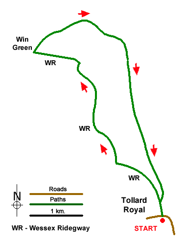
Route Map
Digital Maps - Copyright © 2011-2024. All rights reserved.
Sketch Map
Suggested Maps 

| Ordnance Survey Explorer 184 | Sheet Map | 1:25k | BUY |
| Anquet OS Explorer 184 | Digital Map | 1:25k | BUY |
It is recommended you take a map. The preferred scale is 1:25k.
Start Point Details
Ordnance Survey Grid Ref ST945178
Latitude 50.959598 Longitude -2.079684
Postcode SP5 5PW
what3words start receiving.orbited.fines
Walk description may contain detailed information on the start point for this walk.
Further Information
Wiltshire
Wiltshire is a rural county characterised by its high chalk downland and wide valleys. Salisbury Plain is noted for being the location of the Stonehenge and Avebury stone circles and other ancient landmarks, and as a training area for the British Army. The highest point in the county is the Tan Hill-Milk Hill ridge in the Pewsey Vale, just to the north of Salisbury Plain, at 295 m (968 ft) above sea level. The Marlborough Downs are part of the North Wessex Downs National Landscape (formerly AONB). In the southeast of the county there is a small section of the New Forest.
Walk grading - Learn how each walk is assessed and select a walk to suit your ability and experience by going to Walk Grading Details.
Messaging & Social Media
Message Walking Britain and follow the latest news.

Mountain Weather
Stay safe on the mountains with detailed weather forecasts - for iOS devices or for Android devices.