Bradwell on Sea Circular
Essex Walk
County/Area - Essex
Author - Lou Johnson
Length - 6.5 miles / 10.6 km Ascent - 100 feet / 30 metres
Time - 3 hours 20 minutes Grade - easy
Maps 

| Ordnance Survey Explorer 176 | Sheet Map | 1:25k | BUY |
| Anquet OS Explorer 176 | Digital Map | 1:25k | BUY |
Walk Route Description
Click image to see photo description.
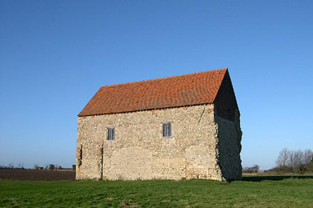
This easy circular walk from Bradwell on Sea in Essex explores a section of countryside and coast. The route allows you to visit one of the oldest churches in England, the isolated seventh-century chapel of St Peter-on-the-Wall. The walk includes Bradwell Waterside with its yachts and small boats, the Blackwater Estuary to visit the Dengle National Nature Reserve with its wide variety of bird life in season.
The start is the car park for Dengle NNR (grid ref. TM024078) on East End Road about 3 km. east of the church in Bradwell on Sea. After parking, return along East End Road and continue ahead to the road junction into the attractive village of Bradwell on Sea with the parish church on your right and the King's Head pub opposite. Turn right into High Street and continue out of the village. Using the grass verge, continue ahead at the first junction past Down Hall on your right to reach a second junction (grid ref. TM002745).
Cross straight over to join a gravel track with an adjacent finger post. The path maintains a diagonal direction across several fields to exit onto Waterside Road in Bradwell Waterside. Bear right and pass Green Man Inn on your right and continue towards the sea. Just before the Yacht Club on the left, turn right onto a narrow path with adjacent finger post (grid ref. TL995079).
The onward path follows the Estuary shore. The first landmark is Bradwell Nuclear Power Station your right. After easy walking for just over three kilometres St Peter's chapel comes into view. Stay on the main path before taking a grassy path on your right towards the chapel (grid ref. TM031082). Continue beyond the chapel to join a track, once a Roman Road, and continue through a kissing gate to reach the car park used at the start of the walk.
Other walks nearby
| Walk 2924 | Tollesbury Wick Marshes from Tollesbury | easy | 7.2 miles |
| Walk 3556 | Arlesford Creek & Brightlingsea Circular | easy | 6.0 miles |
| Walk 3645 | Burnham-on-Crouch to Fambridge | easy/mod | 9.5 miles |
| Walk 3658 | Manningtree, Flatford Mill and Dedham | easy/mod | 7.1 miles |
| Walk 2366 | The Naze from Walton-on-the-Naze | easy | 6.0 miles |
| Walk 3724 | River Box from Stoke-by-Nayland | easy | 6.0 miles |
| Walk 3660 | Stour Valley & Dedham from Flatford Mill | easy | 3.5 miles |
| Walk 2096 | Alton Water, Stutton & Tattingstone | easy | 5.5 miles |
| Walk 2149 | Circuit of Alton Water | easy/mod | 7.6 miles |
| Walk 1648 | Church End & Erwarton from Shotley Gate | easy | 6.0 miles |
Recommended Books & eBooks
No suggestions for this area.Messaging & Social Media
Message Walking Britain and follow the latest news.

Mountain Weather
Stay safe on the mountains with detailed weather forecasts - for iOS devices or for Android devices.