Tinto (northern approach)
South Lanarkshire Walk
County/Area - South Lanarkshire
Author - Lou Johnson
Length - 4.5 miles / 7.3 km Ascent - 1500 feet / 455 metres
Time - 3 hours 50 minutes Grade - moderate
Maps 

| Ordnance Survey Explorer 335 | Sheet Map | 1:25k | BUY |
| Anquet OS Explorer 335 | Digital Map | 1:25k | BUY |
Walk Route Description
Click image to see photo description.
This walk to the summit of Tinto (711 metres) in South Lanarkshire is a popular half day excursion to an excellent viewpoint. This route takes the northern approach and follows clear paths with a steady ascent of the hill. Tinto is an isolated, conical hill on the west bank of the River Clyde.
The start is a small car park (grid ref. NS965365) which lies on a minor road south of the A73 near the Tinto Hill Tearoom. After parking pass through the gate at the southern end of the car park to join a clear path soon passing a bench. The path heads south up the northern flank of Totherin Hill (479 metres). As you gain height you pass a cairn on the left. You can make a short diversion to the cairn before re-joining the main path.
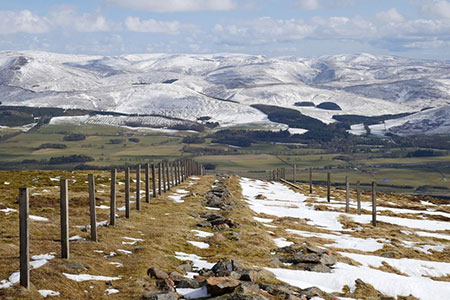
The gradient eases for a short distance before climbing again to reach a path junction (grid ref. NS956354) with the steep sided valley of Maurice's Cleuch below on your right. Take the left fork and continue up the main path. As you gain height the path runs alongside a fence on your right. A steeper section of path leads to the summit which has a large cairn, a trig column which is not the highest point and a topograph which indicates all the main features in view. In fine weather the view includes the Lake District, the mountains of Mourne in Northern Ireland, Ailsa Craig, and Arran in the Firth of Clyde, the Arrochar Alps and as far north as Lochnagar in the Cairngorms.
During your time at the summit, you can often see hang gliders and paragliders. The return route follows the clear path used for the ascent. An alternative path from Wiston on the south side of the hill can be used for descent. This path is steeper and indistinct in places - Tinto from Wiston (southern approach. Also, this descent requires the use of two cars.
Other walks nearby
| Walk 3752 | Tinto from Wiston (southern approach) | moderate | 4.2 miles |
| Walk 2135 | Camps Reservoir Circular | easy | 5.8 miles |
| Walk 3294 | Trahenna Hill from Broughton | moderate | 7.1 miles |
| Walk 2618 | Broad Law & Megget Stone | moderate | 5.0 miles |
| Walk 2268 | Annandale Way | moderate | 9.0 miles |
| Walk 2050 | The Crown of Scotland | moderate | 9.0 miles |
| Walk 2035 | Hart Fell via Hartfell Spa | moderate | 7.2 miles |
| Walk 2280 | Hart Fell & Whitehope Heights | moderate | 8.4 miles |
| Walk 2006 | Grey Mare's Tail & White Coomb | mod/hard | 7.2 miles |
| Walk 3759 | St. Mary's Loch Circular | easy/mod | 7.5 miles |
Recommended Books & eBooks
No suggestions for this area.Messaging & Social Media
Message Walking Britain and follow the latest news.

Mountain Weather
Stay safe on the mountains with detailed weather forecasts - for iOS devices or for Android devices.