Rye Harbour Circular
East Sussex Walk
County/Area - East Sussex
Author - Lou Johnson
Length - 6.0 miles / 9.8 km Ascent - 100 feet / 30 metres
Time - 3 hours 10 minutes Grade - easy
Maps 

| Ordnance Survey Explorer 125 | Sheet Map | 1:25k | BUY |
| Anquet OS Explorer 125 | Digital Map | 1:25k | BUY |
Walk Route Description
Click image to see photo description.
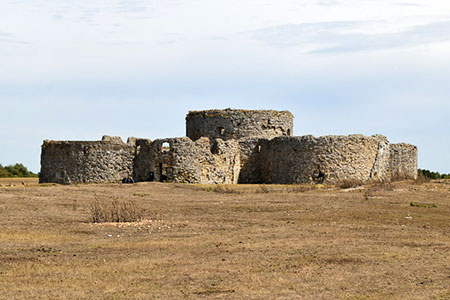
This circular walk explores the man-made lakes of Rye Harbour. The route follows good paths and tracks. The walk is full of interest and includes a Martello Tower used to defend the harbour, a section of beach that extends south to Winchelsea, the Rye Harbour Nature Reserve, and Camber Castle, which became redundant when the shoreline receded.
The walk starts at the large car park at the eastern end of Harbour Road, Rye (grid ref. TQ942190). After parking exit the car park and take the tarmac lane opposite by the Rye Harbour Nature Reserve sign. Continue down the lane passing the Rye Harbour Discovery Centre on your left. You soon pass the red-roofed hut also on your left. $00 metres beyond the hut you reach a junction (grid ref. TQ949181).
Turn left along the back of Rye Harbour Beach. Continue along the surfaced track for 800 metres to reach a bench and information board (grid ref. TQ943178). Turn right here along a gravel track. Continue past a hide on your left and follow the track as it bends to the right and left to reach a junction (grid ref. TQ940181). Go straight ahead here. Follow the track which bends left and then right to pass between repurposed gravel pits to reach a gate.
Just after the gate turn left onto a wider track (Nook Road). Reaching a group of sheds on your left, follow the track as it bends to the left. Continue past a group of buildings on your right and walk ahead to reach a complex junction of tracks and paths (grid ref. TQ925171). Ignore the wider track on your right and take the narrower path also on your right. This path leads through trees, crosses a footbridge, and leads to a track/path junction (grid ref. TQ921173).
Turn right along the track (Morlais Ridge) and continue ahead ignoring a side-track on the left. Follow the track as it bends left. Just before reaching Castle Farm (grid ref. TQ920177), turn sharp right onto a clear track passing a group of trees on your left. Just after the trees fork left and head north. As you approach Camber Castle fork right to pass to the left of the Castle.
Continue past Camber Castle walking north across open ground towards a small group of trees (grid ref. TQ922190). Cross a small stream and fork right keeping the fence on your right. Pass through a gate to enter a field. Follow the fence which should be on your left. Continue along the grassy track for 600 metres to gate (grid ref. TQ928192) where you turn left and continue for 300 metres to a path junction with factories ahead. Turn right and follow the path which parallel to the buildings on your left. Reaching a path junction, veer left and follow the path to reach Harbour Road. Turn right and the car park used at the start is short walk along the road.
Other walks nearby
| Walk 1899 | Royal Military Canal - Cliff End to Seabrook | hard | 29.0 miles |
| Walk 3521 | Wittersham to Rye (High Weald Landscape Trail) | easy/mod | 7.5 miles |
| Walk 1531 | Dungeness & Romney Marsh | easy/mod | 7.5 miles |
| Walk 1353 | Pluckley village circular | easy | 3.7 miles |
| Walk 1838 | Bateman's & Holton Hill | easy | 5.3 miles |
| Walk 3617 | The Wye Downs and Crundale | easy/mod | 6.0 miles |
| Walk 2805 | Chilham circular from Wye | moderate | 17.0 miles |
| Walk 1044 | Wye and the Crundale Downs | moderate | 9.2 miles |
| Walk 2444 | Wye, Crundale & Wye Downs | moderate | 8.6 miles |
| Walk 2923 | Folkestone to Dover along the North Downs Way | easy/mod | 8.2 miles |
Recommended Books & eBooks
No suggestions for this area.Messaging & Social Media
Message Walking Britain and follow the latest news.

Mountain Weather
Stay safe on the mountains with detailed weather forecasts - for iOS devices or for Android devices.