Books and Maps
This section is designed to include a summary of recently published books and mapping useful for all walkers in the British Isles. Links are provided so you can obtain further detailed information and complete on-line purchases.
Cicerone Press 
An excellent range of guides and maps produced by a publisher dedicated to outdoor activities including walking, scrambling and cycling. The following are a selection from their exhaustive catalogue.
Great Mountain Days in Snowdonia
 Inspirational guidebook to 40 great mountain day walks and scrambles in Snowdonia. Inspirational routes for all abilities across the National Park with routes up Snowdon and Moel Eilio, the Glyderau, the Carneddau, Eifionydd, Siabod and the Moelwynion, Rhinogydd (the Harlech Dome), Migneint and the Arans and Cadair Idris and the Tarrens.
More information
Walking the Lake District Fells - Buttermere
 Part of the Walking the Lake District Fells series, this guidebook covers a wide range of routes to 32 Lakeland summits that can be climbed from the Buttermere, Lorton and Newlands valleys, with highlights including Haystacks, High Stile, Grasmoor and the fells of the Coledale Round. Suggestions for longer ridge routes are also included.
More information
Great Mountain Days in the Pennines
 An inspirational guidebook to 50 classic walks on the rolling Pennine landscape. The graded routes, between 6 and 13 miles in length, cover classic Pennine fells and moorland such as Whernside, Ilkley Moor and Pendle Hill; exploring the North and South Pennines, Yorkshire Dales, Howgills and Dark Peak. Many routes are also suited to fell running.
More information
South West Coast Path Map Booklet - Minehead to St Ives
 Map of the northern section of the 630 mile (1014km) South West Coast Path National Trail. Covers the trail from Minehead to St Ives along the north Devon and Cornish coastline. This convenient and compact booklet of Ordnance Survey 1:25,000 maps shows the route, providing all of the mapping you need to walk the trail in either direction.
More information
Lake District: High Level and Fell Walks
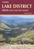 This guidebook describes 30 graded fell walks on the ridges and high peaks of the English Lake District, the UK's most popular national park. Reaching some of England's finest and highest mountain scenery, this guide leads readers to classic horseshoes and traditional ascents as well as lesser-known routes to quieter summits.
More information
The Cotswold Way
 Guidebook to walking the Cotswold Way National Trail. Between Chipping Campden and Bath, the 102 mile route explores the Cotswolds AONB. Described in both directions over 13 stages, the Cotswold Way can be walked year round and is suitable for beginner trekkers. Includes separate OS 1:25,000 map booklet of the route.
More information
Walking in the Yorkshire Dales: South and West
 Part of a two-book set, this guidebook describes 44 walks in the southern and western Yorkshire Dales, including the famous 23 mile Three Peaks circuit over Pen-y-Ghent, Whernside and Ingleborough. The other, mostly circular routes of 3½ to 13 miles cover the scenic region between Sedbergh, Kirkby Lonsdale, Settle, Skipton and Grassington.
More information
Anquet Digital Mapping 
The excellent digital mapping supplied by Anquet is available in a range of formats. Probably the most popular with walkers are their digital format and detailed OS Explorer maps at 1:25k scale. OS Landranger 1:50k maps are also available although showing less detail. Harveys produce Superwalker maps at 1:25k and British Mountain Maps at 1:40k both offering a different style of mapping to the more familiar OS maps. Harvey maps often include additional detail, including more paths, not shown on OS mapping.
For regular walkers there are a number of packages available which offer considerable savings:
| OS Explorer 1:25k Mapping of Complete Great Britain | More Information |
| OS Explorer 1:25k Mapping of British National Parks | More Information |
News & Reviews
A range of product reviews including books and maps are available. The following reviews are the most recent.
Wainwright Hill Bagging Map - A scratchable map showing all 214 Wainwrights in the Lake District. More info.
the people's poncho 2.0 - Lightweight, stylish and lightweight alternative to traditional waterproofs ideal for walkers. More info.
the people's poncho - A durable, lightweight, stylish and compact alternative to traditional waterproofs ideal for walkers with 10% Discount. More info.
AZ Adventure Series Maps - Convenient 1:25000 OS maps in booklet form covering the National Trails of Britain. More info.
Walking in the Aire - A new book by Lee Senior featuring 14 walks in the Aire valley. More info.
West Yorkshire's Wild Side - Two new books in the 'Wainwright' style featuring Calderdale and moorland walks. More info.
Follow Walking Britain for the latest news. 
![]()