Two lakes of the Gwydir Forest - Llyn Elsi and Llyn Parc from Betws-y-Coed
Snowdonia/Eryri Walk
Nat Park - Snowdonia - Eastern Carneddu
County/Area - Conwy
Author - Peter Smyly
Length - 6.5 miles / 10.6 km Ascent - 1300 feet / 394 metres
Time - 4 hours 30 minutes Grade - easy/mod
Maps 

| Ordnance Survey Explorer OL17 | Sheet Map | 1:25k | BUY |
| Anquet OS Explorer OL17 | Digital Map | 1:25k | BUY |
| Ordnance Survey Landranger 115 | Sheet Map | 1:50k | BUY |
| Anquet OS Landranger 115 | Digital Map | 1:50k | BUY |
Walk Route Description
Click image to visit gallery of 6 images.
Before setting off, it is recommended that you obtain a leaflet of the waymarked forest trails in the Gwydir Forest from the information centre in the village of Betws-y-Coed, near to the railway station. A compass, and knowing how to use it, is also useful as forests can be tricky to navigate, due to the lack of clear landmarks and the many tracks, not all of which are waymarked. Paying careful attention in comparing map and compass details with tracks on the ground will help make navigational errors less likely and will increase your enjoyment of the walk as a result.
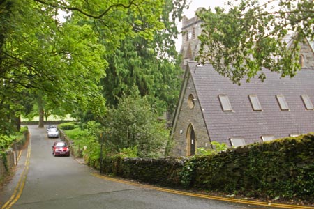
This Snowdonia (Eryri) walk idea would normally be considered as two separate walks, given that Llyn Elsi is in the forest to the south of Betws-y-Coed while Llyn y Parc is in the forest to the north. However, the relatively short length of each walk results in this being a "two in one" walk. Further, as Llyn Elsi is the only lake in the forest to the south, it does not readily link up with other features of note in that part of the forest. There is a car park near Betws-y-Coed railway station and another, smaller one, by the Afon Llugwy (river) adjacent to the green across the road from the station. The walk starts from St Mary's Church, across the main road from the green. Follow the tarmac road up the hill round the corner to the left and a notice board to the right with a map of the route indicates the start of the trail with a time for a round trip given as two hours, including walking around the lake The road leads up the hill between trees, and other vegetation including moss and ferns, gaining height steadily before the gradient eases off. This is the white waymarked trail which shares the same route as the blue waymarked trail to begin with, before they go their separate ways. Follow the main route ahead as it winds its way up through the forest. Ignore any side paths or tracks and stick to the main way ahead. After a walk of about twenty minutes, a T junction is reached with a more open aspect ahead. As the white waymarker at this point indicates, you should turn left here and then the lake can soon be glimpsed in the distance between trees to the right.
Although it is a reservoir which was formerly two smaller lakes, Llyn Elsi is one of the more visually appealing lakes of the Gwydir Forest with its headlands and inlets along with several tree-clad islands. These small islands, when seen more closely, turn out to be rocks. A mixture of coniferous and deciduous trees forms the backdrop to the lake. The islands are a favourite spot for the bird life with which this lake is positively teeming. Their calls, along with the wind blowing gently in the trees are the only sounds you are likely to hear at the lake. A monument overlooks the lake from a slight hill to the north.
The walk route suggests a circuit of the lake in either direction. This route is steep in a few places but none of the steep bits last for very long. The ground to the south of the lake is noticeably higher than to the north. A circuit of the lake does offer the occasional clear view of the lake from different angles though, for the most part, the lake is partially or totally hidden by trees. The path leaves the lake altogether at the southern end before looping back to rejoin it. One break in the trees in particular to the east offers a fine viewpoint along the length of the lake towards the north, the only view of the lake from this side due to the trees.
A walk back down to the church concludes part 1 of the walk.
Part 2 involves turning left along the main road past various shops and then crossing Pont y Pair Bridge to the right. Turn left at the end of the bridge. A worthwhile diversion at this point is to have a closer look at the rocks and waterfalls near the bridge. The route continues up the hill past the car park on the left. Pass a parking space for three or four cars by the road on the left before taking the next road turning on the right between houses. Following this road ahead reveals, on the right, a track wide enough for a vehicle through the forest with "Llyn Parc" indicated on a sign. This is the yellow waymarked trail and, by following it, you will reach Llyn Parc. The route has one main turning, a narrow path uphill, off to the left just when the main route ahead starts to lose height. The yellow trail in its entirety takes about four hours, but a visit to Llyn Parc and back should take no more than about and hour and a quarter from the village. The path going up is noticeably steep in places with rock and mud underfoot . A stream can be glimpsed between the trees below to the right as the route progresses with evidence of former mine workings in places. You pass a mini waterfall on the right, followed by an isolated house on the left and Llyn Parc appears ahead soon thereafter. The lake is long and narrow in a north-south direction, and the dam to the south is reached first where a wooden seat provides a viewing point. To the left, the blue waymarked trail offers possibilities for extending the walk while, the yellow waymarked route continues to the east of the lake. The lake's shore to the east also offers an option, when the water level is relatively low, to walk along the rocks of that shore in a south-north direction. A walk of a few minutes will be enough to be able to see all the way to the far, northern end of the lake. Due to the surrounding forest, a circuit of the lake is not a feasible option. The lake may at first seem rather dull but if, or when, the sun comes out and the trees on either side of it can be seen in different shades of green and brown, it seems quite pretty. Conclude the walk by reversing the outgoing route back to the village.
Other walks nearby
| Walk 1332 | Gwydir ForestLakes from Tyn Llwyn | easy/mod | 6.5 miles |
| Walk 2285 | Llyn Geirionydd & Llyn Crafnant | easy/mod | 5.5 miles |
| Walk 1151 | Moel Siabod | hard | 5.5 miles |
| Walk 2919 | Moel Siabod & Capel Curig | moderate | 6.0 miles |
| Walk 2592 | Llyn Geirionydd & Llyn Bychan from Llyn Crafnant | moderate | 9.5 miles |
| Walk 2608 | Crimpiau & Creigiau Gleision from Llyn Crafnant | moderate | 7.5 miles |
| Walk 2679 | Circuit of Llyn Crafnant | easy | 3.5 miles |
| Walk 2536 | Llyn Crafnant, Capel Curig & Llyn Colwyd from Trefriw | mod/hard | 13.0 miles |
| Walk 3005 | Clogwen | easy | 2.0 miles |
| Walk 2766 | Capel Pinnacle / Y Pincin | easy | 1.0 miles |
Recommended Books & eBooks
Snowdonia: 30 Low-level and easy walks - North
 Guidebook describing 30 walks in Snowdonia, Wales. Routes are mostly low level and on clear paths and showcase the region's beautiful scenery and rich history and culture. Part of a 2-volume set, this northern volume includes the Snowdon area, the Ogwen and Conwy Valleys, Betws-y-Coed, Beddgelert, Ffestiniog and the coast.
More information
The Cambrian Way
 Guidebook to the Cambrian Way, a challenging three-week mountain trek through Wales from Cardiff to Conwy. The 470km un-waymarked route is presented from south to north. Often sticking to long, beautiful ridgelines, it crosses wild and rugged terrain and visits many of Wales's highest mountains, including Snowdon.
More information
Messaging & Social Media
Message Walking Britain and follow the latest news.

Mountain Weather
Stay safe on the mountains with detailed weather forecasts - for iOS devices or for Android devices.