Snowdon by the Pyg and Miner's Tracks from Pen-y-pass
Snowdonia/Eryri Walk
Nat Park - Snowdonia - Snowdon Crib Goch
County/Area - Gwynedd
Author - Lou Johnson
Length - 7.5 miles / 12.2 km Ascent - 2510 feet / 761 metres
Time - 6 hours 20 minutes Grade - moderate
Maps 

| Ordnance Survey Explorer OL17 | Sheet Map | 1:25k | BUY |
| Anquet OS Explorer OL17 | Digital Map | 1:25k | BUY |
| Ordnance Survey Landranger 115 | Sheet Map | 1:50k | BUY |
| Anquet OS Landranger 115 | Digital Map | 1:50k | BUY |
Walk Route Description
Click image to visit gallery of 2 images.
Snowdon is a great mountain and despite the summit crowds is well worth climbing. This route must rank as the easiest. Starting at Pen-y-pass means you have considerably reduced the total ascent and with well-maintained paths for most of the way the going is as easy as it gets in these type of surroundings.
The start for this Snowdonia (Eryri) walk is the car park at Pen-y-pass (grid ref. SH 647555). This car park fills early so the advice is to get there as soon as you can especially when the weather is fine. This route can be attempted in any direction but for the purposes of this description the outward leg uses the Pyg Track with a return along the Miner's Track.
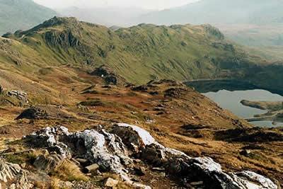
From the car park take the path that exits at the northern end adjacent to the cafe. The first section is dramatic and sets the tone for the whole walk with a great view down to Llanberis. Ahead the east end of Crib Goch can be seen with the great eastern crags of Snowdon leading off to the north. The path climbs steadily to reach a col - Bwlch y Moch - where the path onto Crib Goch leaves to the right.
Staying on the Pyg Track the route continues to climb along the southern flank of Crib Goch with good views right to Llyn Llydaw and Y Lliwedd with Snowdon coming into view ahead. This is some of the grandest mountain scenery in North Wales and despite the steady climb you soon forget the hard work as you enjoy the views. Climbing higher smaller Glaslyn comes into view and it is worth noting where the Miner's Track comes up to meet the path you are on as this will prove useful on the descent.
The relatively easy walk becomes steeper after passing Glaslyn and you climb more rapidly to reach a zigzag which takes you up to a large stone marker at Bwlch Glasw. Again it is worth making a mental note of this for the return journey. You now follow the track of the Snowdon Mountain Railway for the final 300 feet of ascent to the summit.
To return retrace your steps to the stone marker at Bwlch Glasw and descend the zigzag above Glaslyn. You then have a steep descent down to the shores of the lake to join the Miner's Track for the return to Pen-y-pass. Although traversing the same mountainous country the Miner's Track has a different "feel" as the peaks seem higher especially on the section between Glaslyn and Llyn Llydaw. Reaching the shores of the Llyn Llydaw you pass the remains of the mine buildings where Victorian entrepreneurs exploited Snowdon for its copper. Reaching the causeway you can look back to enjoy one of the great views of Snowdon before relaxing on the last almost level stage back to the start.
Other walks nearby
| Walk 2650 | Tryfan, the Glyders & Y Garn | very hard | 8.0 miles |
| Walk 1088 | Glyder Ridge traverse | hard | 5.5 miles |
| Walk 1186 | Y Garn | mod/hard | 4.5 miles |
| Walk 3019 | Y Garn & Carnedd y Filiast Ogwen Cottage | hard | 8.5 miles |
| Walk 3062 | Pen yr Ole Wen | moderate | 5.0 miles |
| Walk 2417 | Glyder Fach, Glyder Fawr and Tryfan from Idwal Cottage | mod/hard | 6.5 miles |
| Walk 1137 | Y Garn (Route 2) from Ogwen Cottage | mod/hard | 4.5 miles |
| Walk 2680 | Circuit of Llyn Idwal | easy | 2.8 miles |
| Walk 1192 | Yr Aran | mod/hard | 6.5 miles |
| Walk 1103 | Snowdon & Cwm Llan horseshoe | very hard | 13.0 miles |
Recommended Books & eBooks
Great Mountain Days in Snowdonia
 Inspirational guidebook to 40 great mountain day walks and scrambles in Snowdonia. Inspirational routes for all abilities across the National Park with routes up Snowdon and Moel Eilio, the Glyderau, the Carneddau, Eifionydd, Siabod and the Moelwynion, Rhinogydd (the Harlech Dome), Migneint and the Arans and Cadair Idris and the Tarrens.
More information
The Cambrian Way
 Guidebook to the Cambrian Way, a challenging three-week mountain trek through Wales from Cardiff to Conwy. The 470km un-waymarked route is presented from south to north. Often sticking to long, beautiful ridgelines, it crosses wild and rugged terrain and visits many of Wales's highest mountains, including Snowdon.
More information
Messaging & Social Media
Message Walking Britain and follow the latest news.

Mountain Weather
Stay safe on the mountains with detailed weather forecasts - for iOS devices or for Android devices.