Fraoch Bheinn Walk
Walk 1163 - Route Maps & Profile
Route Map
Digital Maps - Copyright © 2011-2024. All rights reserved.
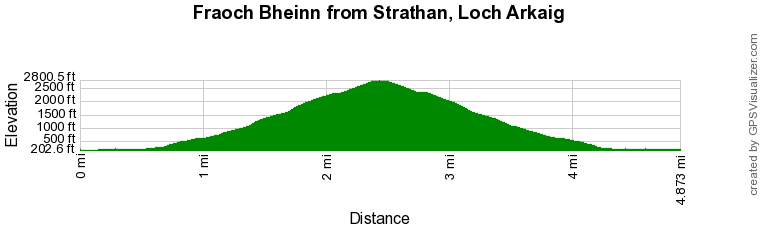
Route Profile
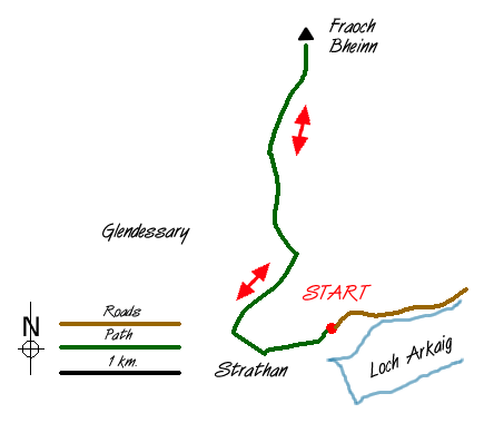
Sketch Map
Suggested Maps 

| Ordnance Survey Explorer 399 | Sheet Map | 1:25k | BUY |
| Anquet OS Explorer 399 | Digital Map | 1:25k | BUY |
| Ordnance Survey Landranger 33 | Sheet Map | 1:50k | BUY |
| Anquet OS Landranger 33 | Digital Map | 1:50k | BUY |
It is recommended you take a map. The preferred scale is 1:25k.
Start Point Details
Ordnance Survey Grid Ref NM987916
Latitude 56.971648 Longitude -5.313456
Postcode PH34 4EL
what3words start clinking.bath.cope
Walk description may contain detailed information on the start point for this walk.
Further Information
Highland
Highland is an administrative area which contains most of the Scottish Highlands. It is sparsely populated and contains some of the finest scenery in the British Isles. High Mountains, deep glens and lochs contain many great walks. The area includes Ben Nevis the highest mountain in the UK. The area also includes part of the Cairngorm National Park, an area of high mountains, and glorious Isle of Skye.
Walk grading - Learn how each walk is assessed and select a walk to suit your ability and experience by going to Walk Grading Details.
Messaging & Social Media
Message Walking Britain and follow the latest news.

Mountain Weather
Stay safe on the mountains with detailed weather forecasts - for iOS devices or for Android devices.