Aran Fawddwy from Cwm Cywarch
Snowdonia/Eryri Walk
Nat Park - Snowdonia - Arans Lake Bala
County/Area - Gwynedd
Author - Lou Johnson
Length - 7.5 miles / 12.2 km Ascent - 2635 feet / 798 metres
Time - 6 hours 20 minutes Grade - mod/hard
Maps 

| Ordnance Survey Explorer OL23 | Sheet Map | 1:25k | BUY |
| Anquet OS Explorer OL23 | Digital Map | 1:25k | BUY |
| Ordnance Survey Landranger 124 | Sheet Map | 1:50k | BUY |
| Anquet OS Landranger 124 | Digital Map | 1:50k | BUY |
Walk Route Description
Click image to visit gallery of 7 images.
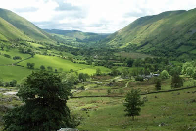
Why do some mountains grab people's attention and others are dismissed? Higher than Bowfell and Great Gable, Aran Fawddwy falls short of the magic 3000 feet by just 31 feet and provides the basis for a quality walk. With outstanding scenery, superb crags and a route that can be followed in either direction it is a perfect candidate for those wishing to avoid the crowds and "bag" a big one. To reach the start, turn off the A470 Mallwyd to Dolgellau road at Dinas Mawddwy. Cwm Cywarch from Dinas Mawddwy is off an unclassified road signed Llanymawddwy, Bala and Llyn Llanwddyn along the Dyfi Valley. The turning for Cwm Cywarch is left at Abercywarch which is approximately 1 mile from the Red Lion at Dinas Mawddwy. Follow the narrow lane up the beautiful valley of Cwm Cywarch to reach a signed car park at grid reference SH852188.
To start the ascent of Fawddwy, continue up the lane following the signed path past Blaencywarch Farm, which nestles beneath the awesome crags of Cwm Cywarch. (Please ensure you follow designated paths in this area as there have been disputes over access in the past and there is no point causing these to start again.) The path begins to climb in a rocky landscape, crossing and recrossing a stream. As height is gained the retrospective view improves and the col beneath Glasgwm is soon reached (grid ref. SH841201).
After admiring the excellent view north to the Rhinog mountains, turn right across the open moorland following the ridge fence as it heads roughly northeast to the summit of Aran Fawddwy, which is now in view. For most of the way there is a path on either side of the fence with little to choose between the two options. About half a kilometre short of the summit a fence comes in from the right. Take note as this is your return route after visiting the summit.
The summit of Aran Fawddwy is dramatic and rocky with a thousand foot drop to the small lake of Creiglyn Dyfi way below. The view north along the ridge to Aran Benllyn is superb with lake Bala providing a fitting backdrop. Elsewhere the panorama includes the Berwyns, some of lesser mountains in the Arans, the Arenigs plus much of northern Snowdonia (Eryri) and mid-Wales.
Turning back regain the fence noted on the ascent and head south alongside it. You soon reach a cairn built in memory of a member of a mountain rescue team killed by lightning, which is perched high above the valley of Hengwm. The path turns east to the summit of Drysgol where there is a fine retrospective of Aran Fawddwy. Turn south once more to the rather boggy col just short of Waun Goch. Here turn south-west on the clear and easy path descending back to the starting point.
I have completed this Fawddwy walk in both directions and in my opinion the route given above is the best. For those with energy to spare an extension along the ridge over Erw y Ddafad-ddu to Aran Benllyn is worth the effort although don't underestimate the extra time needed especially during the short days of winter.
Other walks nearby
| Walk 2937 | Aran Fawddwy northern approach | mod/hard | 8.4 miles |
| Walk 1107 | Waun Oer and Maesglase near Dinas Mawddwy | mod/hard | 11.0 miles |
| Walk 2551 | Rhobell Fawr from near Rhydymain | moderate | 5.7 miles |
| Walk 2811 | Rhobell Fawr and Ddualt from near Rhydymain | moderate | 8.5 miles |
| Walk 1499 | Rhobell Fawr and Dduallt from Llanfachreth | moderate | 12.0 miles |
| Walk 2334 | The Torrent Walk near Dolgellau | easy | 1.6 miles |
| Walk 1646 | The Precipice Walk | easy | 3.5 miles |
| Walk 2475 | The Dyfi Hills Ridge | mod/hard | 9.8 miles |
| Walk 3017 | Aran Benllyn & Aran Fawddwy from Llanuwchllyn | mod/hard | 10.0 miles |
| Walk 2059 | Castell Carndochan near Bala | easy/mod | 2.5 miles |
Recommended Books & eBooks
Snowdonia: 30 Low-level and easy walks - South
 Guidebook describing 30 walks in Snowdonia, Wales. Routes are mostly low level and on clear paths and showcase the region's beautiful scenery and rich history and culture. Part of a 2-volume set, this southern volume includes Trawsfynydd, Bala, Dolgellau, Machynlleth, the Harlech Coast and the valleys of the Mawddach and Dyfi.
More information
The Cambrian Way
 Guidebook to the Cambrian Way, a challenging three-week mountain trek through Wales from Cardiff to Conwy. The 470km un-waymarked route is presented from south to north. Often sticking to long, beautiful ridgelines, it crosses wild and rugged terrain and visits many of Wales's highest mountains, including Snowdon.
More information
Messaging & Social Media
Message Walking Britain and follow the latest news.

Mountain Weather
Stay safe on the mountains with detailed weather forecasts - for iOS devices or for Android devices.