Rhinog Fawr & Gloyw Lyn from Cwm Bychan
Snowdonia/Eryri Walk
Nat Park - Snowdonia - Rhinogs
County/Area - Gwynedd
Author - Lou Johnson
Length - 5.0 miles / 8.1 km Ascent - 1930 feet / 585 metres
Time - 4 hours 30 minutes Grade - mod/hard
Maps 

| Ordnance Survey Explorer OL18 | Sheet Map | 1:25k | BUY |
| Anquet OS Explorer OL18 | Digital Map | 1:25k | BUY |
| Ordnance Survey Landranger 124 | Sheet Map | 1:50k | BUY |
| Anquet OS Landranger 124 | Digital Map | 1:50k | BUY |
Walk Route Description
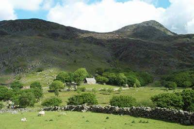
Click image to visit gallery of 7 images.
The Rhinog Mountains have a reputation for providing hard walking. However this excursion avoids the worst and provides a day hike of exceptional quality offering ever changing views and constant interest throughout. The route starts from the car park at Cwm Bychan (grid ref. SH645314), which is reached by taking the minor road from the village of Llanbedr on the A496 a few miles south of Harlech.
To start this Snowdonia (Eryri) walk, exit the car park and turn east along the lane to take the signed footpath on the right. This leads to the Roman Steps climbing at first through pleasant woodland before entering a vast natural "rockery" with the summit of Rhinog Fawr clearly in view. Looking back there is an improving view down into Cwm Bychan with the lake and the rugged outline of Clip completing the picture.
Keep on the main "Roman Steps" path until you reach the col. This path is flagged and progress is fast despite the climb. Reaching the col a grand view opens out ahead with Llyn Trawsfynydd and the mountains of eastern Snowdonia (Eryri) in view. So far the going has been easy but the next section needs care. From the col you need to stay with the main path for about 200 yards to locate another narrower path partly obscured in knee-deep heather, which provides a relatively easy route to Llyn Du. At first the path heads south but soon turns southwest.
Reaching Llyn Du stay on the northern shore and hop across the boulders along the water's edge to reach a clear path that climbs almost due west to reach a wall. Turn left along the wall for a short distance picking up a path that runs east across rock slabs to reach a rough gully. Ascend the gully where hands are needed on a short section to exit onto the summit plateau. A large cairn marks the summit although you need to wander about to enjoy the best views. Away to the south is Rhinog Fach with Y Llethr beyond. Between the two summits can be seen Llyn Hywel.
The easiest return is to follow the outward route but by doing so you miss out on one of the most beautiful locations in Snowdonia (Eryri). Assuming you want to complete a circular walk then head off the summit following a bearing of 240 degrees magnetic, which is only slightly further south than the direction you should have arrived at the summit. An obvious path soon materialises which leads down to a ladder stile at a wall.
You can see Gloyw Llyn below and it is important that you make sure you mentally plot your onward route. It is possible to make out paths across the heather. Using these will reduce the hard slog and make the descent far more pleasant. Cross the stile and continue with the descending path until you are clear of the worst of the boulders then turn northwest across rough heather to pick up the path heading for Gloyw Llyn. This section of the walk is hard to describe but it is clearer on the ground. The path marked on OS maps crosses a wall at grid reference SH645292. If in doubt head for the wall at grid reference SH 648293 further east where you can pick up a path that descends alongside a stream into a small valley. This valley leads directly to the shores of Gloyw Llyn where you will no doubt spend some time absorbing the sheer beauty of the location.
A path meanders along the western shore of the Llyn and this should be followed past the tarn outflow to the northern end of the tarn and then bear north east down to a wall with a ladder stile. Beware there is also a path heading north which leads into the wrong valley! Continue along the path to a fence. Turn right along the fence and continue downwards bearing left with the fence still to your right. In front, down hill is a gate. Go through the gate and follow a fence on your right shoulder. On the other side of that fence is clearly the outward path. There is a new gate through that fence some 150 metres further. Another 150/200 metres gets you back to your car Cwm Bychan.
This walk is not recommended for inexperienced walkers. It is suggested this walk is not attempted in bad weather especially if visibility is poor as the views are worth waiting for and the terrain is confusing. As an added precaution do take a large scale map and a compass. If you lose the path at any point then be patient and spend time trying to relocate it - off path walking is energy sapping and slow going!
Apart from these basic warnings enjoy yourselves - this walk is one of the finest in northern Snowdonia (Eryri)!
Other walks nearby
| Walk 1173 | Moel Ysgyfarnogod & Foel Penolau | moderate | 6.5 miles |
| Walk 2544 | Rhinog Fach circular | moderate | 8.0 miles |
| Walk 1036 | Rhinog Fach & Y Llethr | moderate | 9.0 miles |
| Walk 1194 | Bwlch Drws-Ardudwy | easy | 4.5 miles |
| Walk 3227 | Rhinog Fawr and tarns | mod/hard | 15.0 miles |
| Walk 2713 | Traverse of the Northern Rhinogs from Trawsfynydd | mod/hard | 14.0 miles |
| Walk 1193 | Y Llethr & Diffwys | mod/hard | 11.5 miles |
| Walk 1746 | Bwlch y Rhiwgyr & Pont Scethin | moderate | 9.8 miles |
| Walk 3383 | Morfa Bychan from Borth-y-Gest | easy | 4.0 miles |
| Walk 2336 | Moel-y-Gest | easy/mod | 3.8 miles |
Recommended Books & eBooks
The Wales Coast Path
 A single guidebook to walking the whole Wales Coast Path - 1400km (870 miles) the length of Wales from Chester to Chepstow, including Anglesey, described in 57 stages. The route passes through the Snowdonia and Pembrokeshire National Parks and many AONBs and can be linked with the Offa's Dyke Path for a complete circuit of Wales.
More information
Great Mountain Days in Snowdonia
 Inspirational guidebook to 40 great mountain day walks and scrambles in Snowdonia. Inspirational routes for all abilities across the National Park with routes up Snowdon and Moel Eilio, the Glyderau, the Carneddau, Eifionydd, Siabod and the Moelwynion, Rhinogydd (the Harlech Dome), Migneint and the Arans and Cadair Idris and the Tarrens.
More information
Messaging & Social Media
Message Walking Britain and follow the latest news.

Mountain Weather
Stay safe on the mountains with detailed weather forecasts - for iOS devices or for Android devices.