Walk 1192 - printer friendly version
Yr Aran Walk
Author - Lou Johnson
Length - 6.5 miles / 10.6 km
Ascent - 2300 feet / 697 metres
Grade - mod/hard
Start - OS grid reference SH627506
Lat 53.035004 + Long -4.0490502
Postcode LL55 4NR (approx. location only)
Snowdon is a great mountain but it does suffer from its own popularity and there are few occasions when one can really enjoy it in peace and quiet. An integral part of the main massif, Yr Aran is in contrast a rarely visited peak. It provides an energetic walk with superb views. It also suffers from less cloud cover and is often "cloud free" when its parent summit is hidden from view.
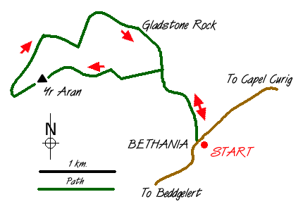
The start of this Snowdonia (Eryri) walk is the car park at Bethania (grid ref. SH627506) on the A498 Beddgelert to Capel Curig road. Cross the main road and walk back to Beddgelert for a few hundred metres and take the signed track that heads north. This is the lower section of the Watkin Path, which is a popular ascent route for Snowdon.
The old mine track climbs steadily with ever improving views. On your right are the waters of Afon Cwm Llan and the waterfalls can be very dramatic especially after heavy rain. After about a mile you enter the dramatic Cwm Llan with the steep southern slopes of Snowdon providing a dramatic backdrop to the scene.
As the view opens up, roughly opposite the old mine building, you will see a trial level on your left. Turn left here (Grid ref. SH620520) and head uphill on an old incline. The going is steep and unremitting and may need the use of hands. Cross an old tramway (Grid ref. SH618519) and continue uphill in the same direction alongside a stream to reach another tramway (Grid ref. SH617518). This is a grassy strip across the hillside and can easily be missed. Turn right along this to reach an abandoned copper mine. From here climb steeply up over an old spoil tip bearing to the north and west of the quarry marked on the map (Grid ref. SH615516) and then grass to reach the ridge. Please be careful in this area as there is an unfenced mine workings that could be dangerous in poor visibility.
Most but not all of the hard work is over when you reach the ridge (Grid ref. SH615515). Turn right and follow the wall west to reach a ladder stile (Grid ref. SH607516) from where a path leads to the summit cairn of Yr Aran. The views more than compensate for the hard work with Snowdon, Moel Siabod, the Nantlle Ridge, Moel Hebog and Mynydd Mawr all competing for your attention.
Leave the summit in a westerly direction, descending until you are able to turn back on grass across the steep northern face of Yr Aran aiming for the small lake at Bwlch Cwm Llan (Grid ref. SH604522). Reaching the col, descend into Cwm Llan turning left off the main path to explore the ruined dressing sheds of the South Snowdon Slate Works. Cross the river and join the Watkin Path, passing the Gladstone Rock, to join your outward route. It is then an easy and pleasant descent back down to Bethania.
Messaging & Social Media
Message Walking Britain and follow the latest news.

Mountain Weather
Stay safe on the mountains with detailed weather forecasts - for iOS devices or for Android devices.