Drosgl and Gyrn Wigau from Rachub
Snowdonia/Eryri Walk
Nat Park - Snowdonia - Western Carneddau
County/Area - Gwynedd
Author - Paul Gasson
Length - 7.5 miles / 12.2 km Ascent - 2250 feet / 682 metres
Time - 6 hours 0 minutes Grade - moderate
Maps 

| Ordnance Survey Explorer OL17 | Sheet Map | 1:25k | BUY |
| Anquet OS Explorer OL17 | Digital Map | 1:25k | BUY |
| Ordnance Survey Landranger 115 | Sheet Map | 1:50k | BUY |
| Anquet OS Landranger 115 | Digital Map | 1:50k | BUY |
Walk Route Description
Click image to visit gallery of 6 images.
This is really a walk for good weather conditions, not only for the views which are superb through 360 degrees, but also because it visits probably the least frequented part of the vast Carneddau range, which require first class navigational skills should the clouds descend, as they all too often do! In poor conditions this route can be a serious undertaking!
The village of Rachub is best approached from the cross roads on the A5, just NW of Bethesda (SH612 677). Drive up the hill to the second X roads, in the centre of the village. Turn left here down a narrow and often congested street with speed humps! until you see the recreation ground on your left. Turn right immediately past it and park on the roadside. Walk up the road to Water Street and immediately opposite is a kissing gate and footpath sign marking the start of the walk. Cross the field to rejoin a road, turn left and almost immediately right up the hill. Follow this road past the Tan y Bwlch Centre. The tarmac soon gives way to a grassy track which ends at gate. Go through the gate to the remains of the Moel Faban slate quarry. Now the walk proper begins. Climb the incline immediately on your left to the first level, then leave it left. Follow the broad grassy track, climbing very gently for a little less than half a mile as it traverses the lower slopes of Moel Faban. To the West extensive views over Anglesey and Ynys Seiriol (named after a 6th.century saint who retired there. Legend has it he built a causeway from the island to the mainland) open up, whilst ahead lies the bulk of Llefn. Beyond Llefn the rocky peninsula of Great Orme thrusts out into the sea. The way ahead can be clearly seen as a grassy track climbing more steeply up the shoulder of Moel Faban but the actual branch off right from the main track is easily missed . Follow the path over the shoulder, with a steep drop into the ravine of Bwlch yn Mhwll-le immediately on your left, until you drop down into the broad valley of the Afon Ffrydlas. Turn left on the crossing path, through a short boggy patch and follow the clear path towards the 'saddle' between the grassy Llefn on the left and the sharply pointed rocky tor of Gyrn ahead. Feral ponies, believed to be the descendants of retired pit ponies, are often seen hereabouts The path bends sharply right to traverse the Eastern side of Gyrn, passing through the tiny ruins of the Gyrn Slate quarry. As you pass Gyrn the path becomes faint, but continue in the same direction until you meet a crossing path which is wider (and often very boggy, choose a dry period!) at SH 651 687.
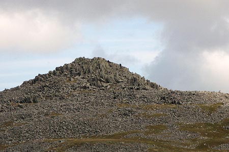
Go right here and follow it easily as it climbs the lower slopes of Drosgl, passing through the ruins of a small building. The path becomes a rocky track beyond and soon reaches the ridge (SH659 677) at a cross roads of paths, marked by a small cairn. Turn left here on the clear track heading directly towards the rocky pile of Bera Bach (The small pyramid). When the track reaches its highest point (SH664 678) leave it left and climb the trackless and grassy slope until the huge (and ruined!) summit cairn of Drosgl (SH663 679) is reached. A smaller cairn marks the actual summit now (758 metres), with a larger wind shelter close by on the North. After admiring the extensive views, either return to the cross roads on the ridge the way you came, or make your way directly towards it.
When you reach the crossroads, continue straight ahead on a narrow, but clear path heading towards the rocky tor of Gyrn Wigau (643 metres). All the way along this ridge there are magnificent views of the high Carneddau (Garnedd Uchaf ( the least visited of the Welsh 14 ( or 15!) Peaks, Carnedd Llewelyn, Yr Elen and the secretive hanging valley of Cwm Caseg, where the feral ponies often have their foals, Carnedd Dafydd, the cliffs of the Black Ladders showing up well and, further away to the South West, the Nant Ffrancon Ridge). Either scramble up to the summit of Gyrn Wigau, or pass below it and follow the now faint path as it crosses the ridge between the summit and smaller rocky tor, and then becomes clearer as it heads, fairly steeply, downhill over grass towards the substantial mountain wall ahead. In bad weather this can be a useful 'handrail' feature. The path curves right just before the wall, and is followed back to Bwlch y Mhwll-le from where you retrace your steps back to the start. Once back at your car back to your car you can reminisce about a glorious day in the solitude of the Carneddau.
Other walks nearby
| Walk 2833 | Moel Faban, Gyrn & Moel Wnion from Rachub | easy/mod | 5.0 miles |
| Walk 2115 | Yr Elen, Carnedd Llewellyn & Carnedd Dafydd | hard | 9.5 miles |
| Walk 2558 | Carnedd Dafydd & Pen yr Ole Wen from Bethesda | mod/hard | 8.0 miles |
| Walk 3051 | Yr Elen from Gerlan | hard | 6.5 miles |
| Walk 3052 | Yr Elen & Carnedd Dafydd from Gerlan | hard | 9.0 miles |
| Walk 1074 | The Glyders Traverse | very hard | 12.0 miles |
| Walk 1453 | Elidir Fawr, Mynydd Perfedd & Marchlyn Mawr reservoir | moderate | 6.0 miles |
| Walk 3020 | Aber Falls, Foel-fras & Drum | mod/hard | 9.0 miles |
| Walk 3021 | Northern Carneddau | mod/hard | 12.0 miles |
| Walk 2346 | Yr Orsedd ridge from near Bont Newydd | moderate | 4.8 miles |
Recommended Books & eBooks
Snowdonia: 30 Low-level and easy walks - South
 Guidebook describing 30 walks in Snowdonia, Wales. Routes are mostly low level and on clear paths and showcase the region's beautiful scenery and rich history and culture. Part of a 2-volume set, this southern volume includes Trawsfynydd, Bala, Dolgellau, Machynlleth, the Harlech Coast and the valleys of the Mawddach and Dyfi.
More information
The Cambrian Way
 Guidebook to the Cambrian Way, a challenging three-week mountain trek through Wales from Cardiff to Conwy. The 470km un-waymarked route is presented from south to north. Often sticking to long, beautiful ridgelines, it crosses wild and rugged terrain and visits many of Wales's highest mountains, including Snowdon.
More information
Messaging & Social Media
Message Walking Britain and follow the latest news.

Mountain Weather
Stay safe on the mountains with detailed weather forecasts - for iOS devices or for Android devices.