Walk 1660 - printer friendly version
Craswall Priory & Hay Bluff Walk
Author - Lou Johnson
Length - 6.0 miles / 9.8 km
Ascent - 550 feet / 167 metres
Grade - easy/mod
Start - OS grid reference SO277360
Lat 52.0176930 + Long -3.0549698
Postcode HR2 0PN (approx. location only)
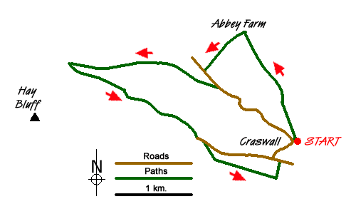
This walk explores the Herefordshire countryside close to the border with Wales and the Black Mountains (which are part of the Brecon Beacons National Park). The route uses a mixture of quiet country lanes, field paths and green lanes and it would be useful to have the correct OS 1:25000 map to help with navigation. The route also passes the remains of Craswall Abbey.
There is limited parking close to the Bull's Head pub (grid ref. SO277360). It is worth noting that this is the only source of refreshment on this walk. From the road junction by the pub, walk north along the lane to reach St Mary's church on your right. Bear right just after the church and then almost immediately left onto a signed bridleway. Follow this to Abbey Farm (grid ref. SO273378). Turn left here, with the farm on your right, to pass the remains of Craswall Abbey on your left and walk up to the road.
Turn left along the road as far as a small copse on your left. Here leave the road and follow the bridleway heading northwest at grid ref. SO270370. Stay on this bridleway (the Three Rivers Ride) as it climbs easily to reach the Welsh Border at a broad col (grid ref. SO251373). You have also entered the Brecon Beacons National Park. There are a number of paths in this area and it is important that you locate the return route to the start. Just prior to the border you will have passed a small wooded area on your right. The onward route runs parallel to the southern boundary of this wood.
Having enjoyed the views from the highest point of walk with Hay Bluff easily recognised, turn around and follow the bridleway through open country along the southern side of the small wood keeping the boundary of the open country on your left. The route the enters an enclosed green lane and continues to a point where a tarmac lane appears on the left (grid ref. SO267362). Ignore the tarmac lane, instead veering right to continue following the green lane in a south-easterly direction. After about three quarters of a mile you reach a bridleway junction at grid ref. SO278357. Turn left here, and walk to the road. The start of the walk is a few yards along this road to your left.
Messaging & Social Media
Message Walking Britain and follow the latest news.

Mountain Weather
Stay safe on the mountains with detailed weather forecasts - for iOS devices or for Android devices.