Walk 1813 - printer friendly version
Sgurr Dhomhnuill Walk
Author - Tony Maries
Length - 8.0 miles / 13 km
Ascent - 2460 feet / 745 metres
Grade - mod/hard
Start - OS grid reference NM838665
Lat 56.739871 + Long -5.536754
Postcode PH36 4JB (approx. location only)
Sgurr Dhomhnuill is the highest peak in Ardgour and Ardnamurchan and on a fine day provides unforgettable views over a huge area of the West Highlands. There are two 'standard' approaches, one from Strontian to the south west through the Ariundle oak woods and one from the east along Glen Scaddle. The walk from Strontian is interesting as far as the end of the woods, then dull thereafter, and the walk along Glen Scaddle is very long. This walk describes a third approach from the minor road from Strontian to Polloch.
This walk could be combined with either the standard approaches if you can arrange how to get back to the starting point. My comments on my Ben Resipol walk also apply here. Start from the mobile phone mast at the top of the Bealach Fèith nan Laogh (Grid ref. NM838665). A car can be parked opposite the mast installation.
The walk is rough, pathless and bouldery where it is not boggy. As soon you step off the road, the 'splotch' sound as your boots sink into saturated ground, familiar to anyone who knows the West Highlands, tells you what sort of day it is going to be. The Gaelic names tell you a great deal about the ground covered by this walk. Sgurr is sharp-pointed peak, Garbh means rough, Clachaig stony, Sgiath knife. Few people will maintain anything like a Naismithian pace. The views on a fine day, however, will more than make up for wet feet.
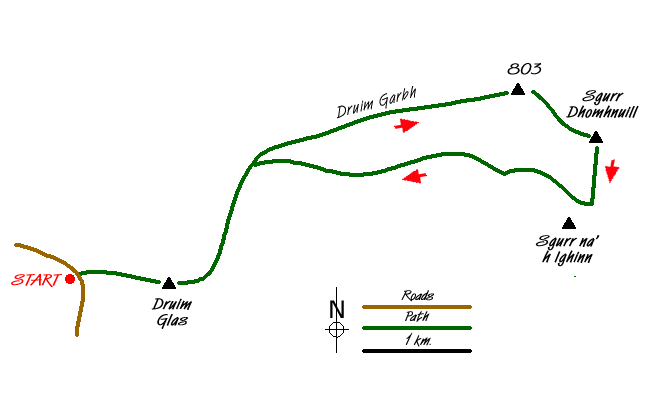
From the mast, walk east up the grassy west end of Druim Glas. Head for the 435m triangulation pillar (1 km), then steer north-east through a maze of tiny lochans, aiming for the 580m minor height above the Lochan Mhic Gille Dhuibh. The ground becomes steadily rougher (and less boggy) as you gain height and reach the Druim Garbh. The narrow Bealach Clachaig imposes a temporary interruption to your steady progress up the mountain. From the 700m height above the bealach views of a large part of the West Highlands start to unfold.
Next, aim for the 803m peak above the Glas Bealach. This is not named by the Ordnance Survey, and is the highest point of the Druim Garbh ridge. From the top, walk down to the Glas Bealach (watershed about 640m). Although Glas means green, the bealach is not particularly grassy as the name suggests, it is just a little less stony than the mountains to either side.
From the bealach, walk straight up the north face of Sgurr Dhomhnuill. The side of the mountain is steeply sloping broken crag and rock, but any major difficulties can easily be avoided, usually by going round to the west. Near the top of the mountain, a faint path appears in places and follows a slightly easier line to the south-west before climbing up to the top. There is a very large cairn on the top, with a hollow centre. If accompanied and you are the first to arrive at the top, the inside of the cairn provides the ideal opportunity to confuse your companions. Watch them looking puzzled when they arrive to see that you are not there. Then watch them walk round and round the cairn, then start with mounting concern to peer over the edge of the steeper precipices.
The top provides extensive views towards the mainland, with Ben Nevis, the Mamores, Aonach Eagach and Bidean nam Bian at much closer quarters than from neighbouring Resipol. To the north, the rough unpopulated wilderness of the interior of Ardgour is very similar to Knoydart. The crumpled and craggy north side of Garbh Bheinn is well seen, too.
While I was looking for information on Dhomhnuill an obscure academic discourse used the grand phrase 'discontinuous granitic gneiss' to sum up the local geology. Whether the discontinuity refers to the nature of the rock, or the fractured landscape, with deep steep-sided glens separating mountain peaks, was not explained. The phrase is memorable, even if the rest of the piece was not compelling reading. Rather than the commonplace grey schist the feldspar, mica and quartz of the local rock lends itself to attractive banding patterns. Must continue with the walk, before I get quoted by somebody else.
The best descent of the mountain is down the south face to the bealach below Sgurr na h-Ighinn. If any energy remains you could scale Sgurr na h-Ighinn too, which is less than 100m re-ascent from the bealach. Descend along a burn to the Ruighe Bealach Clachaig. Once down to about 470m, cross over to the north side of the Allt Feith Dhomhnuill and walk west along the side of the Druim Garbh. Staying at about a height of 450m will keep you above the boggy bottom of the glen, and reduce the amount of height that needs to be regained further down the glen. There is no path, and any walker with his left leg six inches longer than the right will have a considerable advantage.
Once opposite the disused Bellsgrove lead mines at the end of the Druim Leac a'Sgiathain, climb up onto the Druim Glas to regain the line of the outward route. Very little to be seen of the remains of the lead mines, although the current workings on the west side of the road to Polloch show what the mountain side must once have looked like.
Near the end of my walk, there was a herd of cows high on the Druim Glas. It was quite a still day, and they had moved up to higher ground to get away from the midges. The local farmers usually turn their cattle onto the mountain in the summer, as what little good low-lying pasture there is, is needed to grow grass to make silage for winter feed. It is usually easy to spot grass that has been grazed by cattle. Because cattle only have incisor teeth on the lower jaw, they tear off grass with the aid of their tongue. The grass blades are left with ragged ends, unlike grass cropped by sheep or deer, which is smoothly broken off.
Messaging & Social Media
Message Walking Britain and follow the latest news.

Mountain Weather
Stay safe on the mountains with detailed weather forecasts - for iOS devices or for Android devices.