Walk 1883 - printer friendly version
Advent Church Walk
Author - Lou Johnson
Length - 5.2 miles / 8.5 km
Ascent - 500 feet / 152 metres
Grade - easy
Start - OS grid reference SX115798
Lat 50.5874270 + Long -4.6642708
Postcode PL32 9PZ (approx. location only)
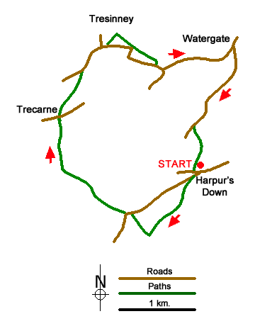
A pleasant walk on the northern edge of Bodmin Moor starting from Harpur's Downs. The route offers views to Brown Willy, the highest point in Cornwall and nearby Rough Tor. During the walk you will pass two abandoned settlements with remnants of the longhouses seen in the landscape. The route also visits the isolated Advent church near Tresinney which lies a considerable distance from its parishioners.
The start is the road junction on Harpur's Downs (grid ref. SX115798) where parking is available on the grassy triangle between the roads. After parking, head southwest across grass to a stile. The path then keeps to the left-hand side of several fields before passing through a small wood to reach a track Turn right past Newton Farm and continue along the farm's access track to a road (grid ref. SX107793).
Turn left and where the road bends left continue ahead onto a track. Pass through a yard and continue along an obvious sunken track passing the site of the medieval village of Carweather. Follow the track downhill to gate and shortly after a barn. Keep to the right and continue over a cross a clapper bridge over the River Camel to reach a lane (grid ref. SX098806). Turn right and immediately left to pass through wooden gate into a field. Keep to the right-hand side of two fields. Entering the third field head straight across to reach a lane (grid ref. SX100812).
Turn right along the lane towards Tresinney. Follow the lane for 350 metres to reach a junction. Turn right and continue to the next junction. Keep ahead at the next junction and continue to a fingerpost on the left signed to Advent Church. Leave the churchyard at the eastern end crossing stile ignoring the path on the right. Follow path over five fields. Exit the last filed via a stile onto a lane (grid ref. SX110812). Bear left up the lane and continue for a kilometre to the next junction at Watergate (grid ref. SX120814).
Turn right and follow the lane for 1.4 kilometres. Turn left over stile by a metal gate (grid ref. SX114804). Descend the slope with a hedge on your right, cross a stream, using stepping stones, and continue along the waymarked path uphill and back to the start at Harpur's Downs.
Messaging & Social Media
Message Walking Britain and follow the latest news.

Mountain Weather
Stay safe on the mountains with detailed weather forecasts - for iOS devices or for Android devices.