Worms Head from Rhossili
Gower Peninsula Walk
Region - Gower Peninsula
County/Area - Swansea
Author - Lou Johnson
Length - 3.3 miles / 5.4 km Ascent - 450 feet / 136 metres
Time - 2 hours 10 minutes Grade - easy
Maps 

| Ordnance Survey Explorer 164 | Sheet Map | 1:25k | BUY |
| Anquet OS Explorer 164 | Digital Map | 1:25k | BUY |
Walk Route Description
Click image to see photo description.
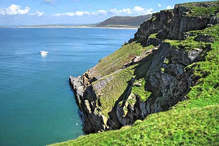
An excellent short walk on the Gower Peninsula starting from Rhossili. The route crosses farmland to join the Wales Coast Path which is followed along a scenic section of coast to Worms Head. If tides permit, you can explore the rocky headland. The walk returns to Rhossili with excellent views across the bay and down.
The walk starts from the large pay and display Rhossili Bay car park (grid ref. SS414881) adjacent to the National Trust Rhossili and South Gower Coast visitor centre. There are also public toilets. After parking, walk to the car park entrance and follow the B4247. Follow the road until it bends left and take the track on the right alongside a garage with a telegraph pole (grid ref. SS416880).
Follow the track for 250 metres to a T-junction and turn left. Continue along the enclosed path to return to the B4247 in Middleton. Turn right along the B4247 and after 200 metres, turn right between buildings (broken fingerpost). Follow the path down to a valley, Mew Slade (grid ref. SS424875). Turn right along the upper path which soon joins the Wales Coast Path.
Continue along the clifftop coast path with the beach below on your left and continue to Tears Point. Continue on the coast path as it bends sharp right heading towards the coastguard hut from where you get a fine view to rocky Worms Head. If tides permit, you can descend steps down to the causeway which links the mainland with Worms Head. A path leads all the way over Inner Head to Worms Head. Allow about an extra 45 minutes for this option. From the coastguard hut continue along the Wales Path heading north-east towards Rhossili to reach the carpark.
Other walks nearby
| Walk 1960 | Worms Head from Pilton Green | easy/mod | 7.5 miles |
| Walk 2144 | Port-Eynon from Pilton Green | easy/mod | 6.4 miles |
| Walk 1691 | Whiteford Point & Broughton Bay from Llanmadoc | easy/mod | 8.5 miles |
| Walk 2724 | Whiteford Sands from Llanmadoc | easy | 5.1 miles |
| Walk 2191 | Cheriton & Weobley Castle from Landimore | easy/mod | 5.2 miles |
| Walk 2277 | Oxwich Point Circular from Oxwich | easy/mod | 3.5 miles |
| Walk 2287 | Cefn Bryn & Penrice | easy/mod | 7.7 miles |
| Walk 3761 | Cefn Bryn & Three Cliffs Bay from Penmaen | moderate | 9.0 miles |
| Walk 2358 | Parc le Breos near Parkmill | easy | 3.6 miles |
| Walk 1828 | Three Cliff Bay & Ilston Cwm from Southgate | easy/mod | 9.0 miles |
Recommended Books & eBooks
No suggestions for this area.Messaging & Social Media
Message Walking Britain and follow the latest news.

Mountain Weather
Stay safe on the mountains with detailed weather forecasts - for iOS devices or for Android devices.