Walk 1974 - printer friendly version
Lyveden New Bield from Wadenhoe Walk
Author - Lou Johnson
Length - 8.2 miles / 13.3 km
Ascent - 450 feet / 136 metres
Grade - easy/mod
Start - OS grid reference TL011833
Lat 52.4383310 + Long -0.5141827
Postcode PE8 5ST (approx. location only)
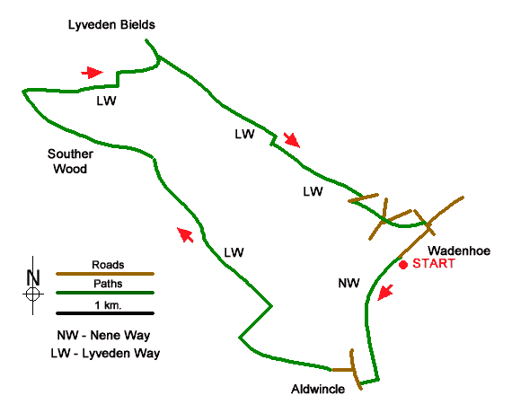
The highlight of this interesting walk from Wadenhoe (Northants) is Lyveden New Bield, an unfinished house built about 1605 and now managed by the National Trust. The route follows the Nene Way south to Aldwincle where the walk turns north across farmland and through woodland to follow the Lyveden Way.
The walk starts from the Village Hall in Wadenhoe (grid ref. TL011833). After parking turn left onto a footpath signed Lyveden Way. Almost immediately fork left off the main path to join the Nene Way. Initially the path runs near the River Nene into woodland. Exiting the trees, the path veers slightly right across a field before running down the edge of a wood. Continue across fields for a further 400 metres and turn right following the waymarked Nene Way. Continue to reach Main Street in Aldwincle (grid ref. TL005819).
Turn right and after 150 metres turn left into Cross Lane. Continue ahead for just over a kilometre to reach a junction in trees (grid ref. SP993824). Turn right and follow the track edged by trees for 400 metres to a fingerpost on the left (grid ref. SP996827). Turn left, re-joining the Lyveden Way. The path follows a hedge on your left across two fields before briefly passing between hedges into a field. Keep ahead and follow the path along the edge of Green Side Wood. Reaching a junction follow the waymarked path left through Lady Wood.
Leaving the trees, you soon reach a path junction (grid ref. SP971849). Turn right and follow the path across fields with the wood on your right. The waymarked path turns left and shortly after left before continuing to Lyveden. Allow time to explore this interesting site. To return to Wadenhoe, take the signed path from the southern end of the car park following the direction indicated by the fingerpost. The route crosses a field to enter Lifford Wood. Exiting the wood, the path continues across two fields to join a clear track with trees to your left. Follow the track as it bends right and then turn left as indicated by the waymarks (grid ref. SP996844).
Continue ahead to a lane and turn right. After 150 metres turn left onto a signed footpath across a field to another lane. Go straight across and follow the waymarked path back towards the centre of Wadenhoe. Reaching Main Street, turn right and at the first junction keep right into Mill Lane. Take the next road on the right (signed Nene Way) and return to the start.
Messaging & Social Media
Message Walking Britain and follow the latest news.

Mountain Weather
Stay safe on the mountains with detailed weather forecasts - for iOS devices or for Android devices.