Walk 1981 - printer friendly version
Epwell from Sibford Gower Walk
Author - Lou Johnson
Length - 5.6 miles / 9.1 km
Ascent - 400 feet / 121 metres
Grade - easy/mod
Start - OS grid reference SP353379
Lat 52.0383840 + Long -1.4867867
Postcode OX15 5RW (approx. location only)
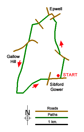
Oxfordshire walk from the attractive village of Sibford Gower with some buildings built from the local ironstone. The route crosses an undulating landscape to Epwell following the D'Arcy Dalton Way. Turning south the walk continues on the Macmillan Way along Ditchedge Lane before returning to the start using field paths.
The start is the centre of Sibford Gower (grid ref. SP353379) where limited on street parking is available. After parking walk east along Main Street (signed to Burdrop). Continue past the church on your right and follow the road as it bends right to a junction. Turn left (signed Swalcliffe) and then take the first signed footpath on the left. You are now following the D'Arcy Dalton Way., Walk north across two fields to reach the B4035). Turn left and walk along the grass verge for 200 metres and join the first footpath on the right by a metal gate. Once through the gate bear half-left and continue across fields soon passing a barn on your left. Continue north crossing a track (grid ref. SP355398).
As you near Epwell you reach a bridleway. Bear right to reach Sibford Road in Epwell. Take the second road on the left (signed Epwell Village) to reach The Square. Turn left passing the church on your left. At the next junction turn left and follow the lane as it bends right. Take the next footpath on the left (MacMillan Way) just before a house named "Ambleside". There is a fingerpost, but it is hidden in undergrowth (grid ref. SP3524050). The path enters a field where you keep right and at the end of the field turn right and then almost immediately left keeping to the right-hand side of two fields. Reaching a road turn right and then take the first path on the left.
Cross a field to a track (Beggars Lane) and turn left. After 700 metres you join the B4035, turn right and continue past a lay-by and then turn left through a metal gate to join a track (Ditchedge Lane) with hedges either side. You are now following the Macmillan Way south. Following the clear path for about two kilometres ignoring paths and bridleway left and right. Pass Rye Hill Farm on your left and at the next junction (grid ref. SP339373) turn left and follow a clear track downhill. Just past Hayne's Barn (grid ref. SP341373) turn left onto a footpath. The path goes half-right down several fields into a broad valley. Cross the stream and head uphill back to the start in Sibford Gower.
Messaging & Social Media
Message Walking Britain and follow the latest news.

Mountain Weather
Stay safe on the mountains with detailed weather forecasts - for iOS devices or for Android devices.