Walk 1988 - printer friendly version
Beddgelert, Moel Hebog, Meol yr Ogof & Moel Lefn Walk
Author - Lou Johnson
Length - 6.8 miles / 11 km
Ascent - 3450 feet / 1045 metres
Grade - mod/hard
Start - OS grid reference SH587481
Lat 53.011504 + Long -4.1075646
Postcode LL55 4YJ (approx. location only)
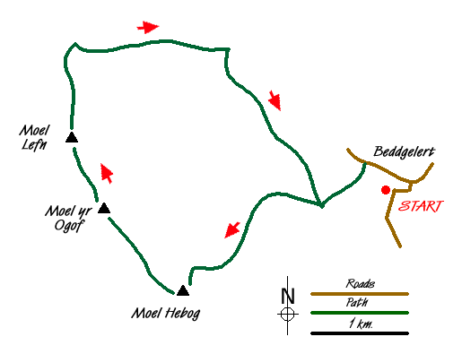
Moel Hebog (782m.) rises to the west of the village of Beddgelert and is the most dominant mountain when standing in the village centre. This Snowdonia (Eryri) walk provides a straightforward ascent with some marvellous views enjoyed throughout the route. Also included are the summits of Moel yr Ogof and Moel Lefn on Moel Hebog's northern ridge. Do remember that this is a serious mountain route and you should be well prepared before setting out. There is one section that requires limited use of hands and good route finding ability is required for the section through the forest during the descent.
There is a large car park (grid ref. SH587481). Exit the car park and walk to the centre of the village and follow the A4085 towards Caernarfon. After about 500 metres from the road junction in the centre of the village, turn left over the river bridge. Follow this clear track past a couple of farmhouses and through woods to reach a barn (Grid ref. SH581479). Immediately after the barn there is a gate. Go through this and follow the path, which is reasonably well defined and has route markers at low level.
After a short distance from the barn the climbing starts and it is a steep pull all the way to the summit of Moel Hebog. The path continues on an ill-defined ridge and continues to the left of the spectacular crags, Y Diffws, after which there is some light scrambling. Looking back you get a superb view of Snowdon together with terrific views to Beddgelert and the Dinas Valley.
The path becomes rocky and is marked by piles of stones. This section leads to a grassy shoulder which in turn leads to another short rocky section and the summit plateau. Most of the ascent is now complete and you can enjoy the views. Snowdon is well known but some lesser known peaks to the north including Mynydd Drws-y-coed. In addition Mynydd Graig Goch at the western end of the Nantlle ridge is also prominent.
From the summit of Moel Hebog the next leg of the walk heads north following the wall steeply downhill to a col with some impressive rock formations at the foot of Moel yr Ogof. From here it is a short but steep climb to the top of Moel yr Ogof. This peak has strong connections with Owain Glyndwr who is reported as using a cave as a hiding place. Leave Moel yr Ogof and walk north descending to a col before climbing onto the summit of Moel Lefn.
Descend north on the clear ridge path passing a deep quarry on your left to reach the edge of the forest at Bwlch Cwm-trwsgl (grid ref SH553496). Turn right over the stile and descend through the forest. Good map reading skills are essential for this section. Despite the path it is easy to go off route and you need to check your position regularly. The path enters open mountainside with the ridge of Castell to your right.
Re-entering the forest the path drops down to Hafod Ruffydd Uchaf (grid ref SH570496). Here you turn right (south) on a clear track back towards Beddgelert. Generally the way ahead is easy to follow but there are some dead ends to what appear to be useful tracks. Do check on the map and aim initially for the footbridge (grid ref. SH573491). From here continue to Meillionen from where the route takes you south to the join your outward route from the bridge on the Caerfnarfon road. If you have trouble negotiating the forest tracks around Meillionen then drop down through the campsite to the main road and use this for the way back to Beddgelert.
Messaging & Social Media
Message Walking Britain and follow the latest news.

Mountain Weather
Stay safe on the mountains with detailed weather forecasts - for iOS devices or for Android devices.