Woodford & Hollygrove Wood Walk
Walk 1996 - Route Maps
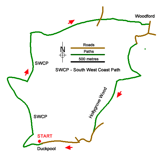
Route Map
Digital Maps - Copyright © 2011-2024. All rights reserved.
Sketch Map
Suggested Maps 

| Ordnance Survey Explorer 126 | Sheet Map | 1:25k | BUY |
| Anquet OS Explorer 126 | Digital Map | 1:25k | BUY |
It is recommended you take a map. The preferred scale is 1:25k.
Start Point Details
Ordnance Survey Grid Ref SS202117
Latitude 50.876754 Longitude -4.557066
Postcode EX23 9JN
what3words start rhino.itself.hoaxes
Walk description may contain detailed information on the start point for this walk.
Further Information
Cornwall
With a long and varied coastline Cornwall offers walkers many wonderful walks using sections of the South West Coast Path National Trail. In places the coastal scenery is very rugged and the walking often quite strenuous. Inland the moors of West Penwith and Bodmin offer a dramatic change of scenery to that encountered on the coast. Further interest is added by pretty villages and harbours, industrial archaeology, mostly focused on the former tin mines, and some outstanding archaeology sites especially in the moorland areas.
Walk grading - Learn how each walk is assessed and select a walk to suit your ability and experience by going to Walk Grading Details.
Messaging & Social Media
Message Walking Britain and follow the latest news.

Mountain Weather
Stay safe on the mountains with detailed weather forecasts - for iOS devices or for Android devices.