Yr Elen, Carnedd Llewellyn & Carnedd Dafydd
Snowdonia/Eryri Walk
Nat Park - Snowdonia - Western Carneddau
County/Area - Gwynedd
Author - Peter Smyly
Length - 9.5 miles / 15.4 km Ascent - 3400 feet / 1030 metres
Time - 8 hours 10 minutes Grade - hard
Maps 

| Ordnance Survey Explorer OL17 | Sheet Map | 1:25k | BUY |
| Anquet OS Explorer OL17 | Digital Map | 1:25k | BUY |
| Ordnance Survey Landranger 115 | Sheet Map | 1:50k | BUY |
| Anquet OS Landranger 115 | Digital Map | 1:50k | BUY |
Walk Route Description
Click image to visit gallery of 8 images.
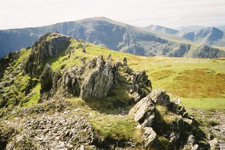
This Snowdonia (Eryri) walk features three of the Welsh mountains that rise to over three thousand feet above sea level in a roughly circular route - Yr Elen (3,156 feet), Carnedd Llewellyn (3.491 feet) and Carnedd Dafydd (3.425 feet). In the early stages of this walk you need good navigational and map reading skills.
Although Idwal Cottage offers a more direct approach to the Carneddau, by starting at the Welsh town of Bethesda to the west, a round trip is more easily achieved. This walk could be done in either a clockwise or an anti-clockwise direction. Having done the route in each direction, my own preference is for a clockwise approach. The main reason is that you are spared the long, steep haul up to Carnedd Dafydd's summit plateau from Foel Meirch which can seem an interminably long slog, although its only about eight hundred feet, which is not a huge amount in the context of the overall height gain of this walk.
There is no car park in Bethesda, but the best option is to leave the car by one of the roadsides to the east of the village. The walk-in follows pathless terrain across a grassy valley, following the course of the Afon Caseg (river) with the objective of climbing Yr Elen first via Cwm Caseg, home to the tarn of, fittingly enough, Ffynnon Caseg. Typically of the Carneddau, it is necessary to walk across long grassy stretches to reach more interesting terrain later on. The less interesting phase is well worth it once the climb up Yr Elen starts gaining altitude in earnest and the jagged ridge leading to the summit is reached. The route heads up Yr Elen with the oblong shaped Ffynnon Caseg below to the left. Yr Elen is an "outlier" if doing a long traverse of the Carneddau end-to-end, but it fits in neatly as part of a circular route such as this.
The summit is a mixture of grass and rocks with the highest point not being immediately obvious as there is no trig point or cairn; rather unusual, given that this is one of the highest peaks in Wales. The ridge of Mynydd Du, leading up to Carnedd Dafydd, can be seen across Cwm Llafar to the south west from the summit area. An obvious path now descends down into a dip, passing near the edge of Cwm Caseg to the left before rising steeply again up a rocky slope to lead to the similarly rocky Carnedd Llewellyn summit plateau. A wind shelter appears near the summit of this, the fourth highest mountain in Wales, and it offers some respite in the event of adverse weather conditions.
The Glyderau appear to the left on the descent down to the next dip, Bwlch Cyfryw-drum, before the gradient climbs more gradually along the Cefn Ysgolion Duon ridge to Carnedd Dafydd, the third and final summit, and the third highest mountain in Wales after Snowdon and Garnedd Ugain. In common with Carnedd Llewellyn, there is a wind shelter and a large cairn. This is a good spot to stop for a break before tackling the steep rocky descent. The minor top of Foel Meirch is passed on the way down before passing along the Mynydd Du ridge. There is one section where there are boulders to clamber over before Mynydd Du. The easiest way of regaining the start is to join the path following the Afon Llafar. This leads out to a lane which can be followed back into Bethesda.
Editor's Note - when preparing this walk for publication I assumed a start in Gerlan (where there is some limited parking). The maps and GPX file have been constructed on this basis. From the start point walk southwest to the road junction at grid ref. SH633662. Turn left here and continue along the lane and track out into open country and the valley of the Afon Caseg. This avoids some wet ground. On the return leg descend the Mynydd Du ridge and pick up the path going northwest roughly parallel to the Afon Lafar. This path leads back to a lane which is followed back to the start.
Other walks nearby
| Walk 3051 | Yr Elen from Gerlan | hard | 6.5 miles |
| Walk 3052 | Yr Elen & Carnedd Dafydd from Gerlan | hard | 9.0 miles |
| Walk 2558 | Carnedd Dafydd & Pen yr Ole Wen from Bethesda | mod/hard | 8.0 miles |
| Walk 2833 | Moel Faban, Gyrn & Moel Wnion from Rachub | easy/mod | 5.0 miles |
| Walk 1074 | The Glyders Traverse | very hard | 12.0 miles |
| Walk 1315 | Drosgl and Gyrn Wigau from Rachub | moderate | 7.5 miles |
| Walk 1453 | Elidir Fawr, Mynydd Perfedd & Marchlyn Mawr reservoir | moderate | 6.0 miles |
| Walk 1088 | Glyder Ridge traverse | hard | 5.5 miles |
| Walk 1186 | Y Garn | mod/hard | 4.5 miles |
| Walk 3019 | Y Garn & Carnedd y Filiast Ogwen Cottage | hard | 8.5 miles |
Recommended Books & eBooks
The Wales Coast Path
 A single guidebook to walking the whole Wales Coast Path - 1400km (870 miles) the length of Wales from Chester to Chepstow, including Anglesey, described in 57 stages. The route passes through the Snowdonia and Pembrokeshire National Parks and many AONBs and can be linked with the Offa's Dyke Path for a complete circuit of Wales.
More information
Great Mountain Days in Snowdonia
 Inspirational guidebook to 40 great mountain day walks and scrambles in Snowdonia. Inspirational routes for all abilities across the National Park with routes up Snowdon and Moel Eilio, the Glyderau, the Carneddau, Eifionydd, Siabod and the Moelwynion, Rhinogydd (the Harlech Dome), Migneint and the Arans and Cadair Idris and the Tarrens.
More information
Messaging & Social Media
Message Walking Britain and follow the latest news.

Mountain Weather
Stay safe on the mountains with detailed weather forecasts - for iOS devices or for Android devices.