Walk 2140 - printer friendly version
Christmas Common & Greenfield circular Walk
Author - Lou Johnson
Length - 7.8 miles / 12.7 km
Ascent - 950 feet / 288 metres
Grade - easy/mod
Start - OS grid reference SU710935
Lat 51.6358360 + Long -0.9754950
Postcode OX49 5HS (approx. location only)
This Oxfordshire walk from Christmas Common explores an area of countryside and woodland on the western edge of the Chilterns. The route follows sections of the Oxfordshire Way, The Ridgeway and Chiltern Way together with paths and bridleways. A section of the walk follows the foot of the Chilterns escarpment and there are some good views northwest across Oxfordshire. The area covered by the walk frequently sees red kites soaring above the landscape.
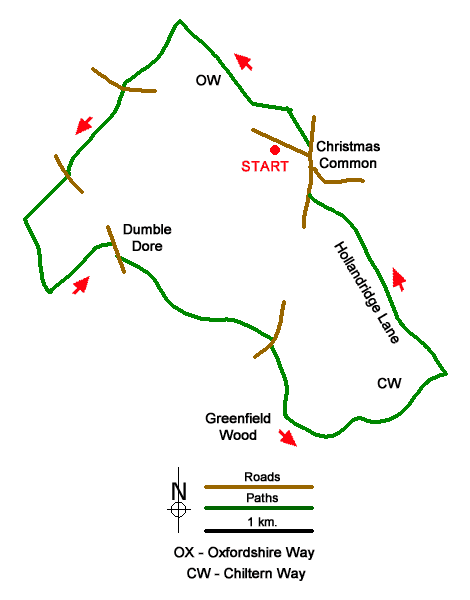
The walk starts from the National Trust car park on the eastern slopes of Watlington Hill (grid ref. SU710935). After parking, exit the car park and turn right along Hill Road into the village of Christmas Common. Reaching a T-junction, turn left to Stokenchurch. After 50 metres turn left at the footpath fingerpost to join the Oxfordshire Way (grid ref. SU714935). Continue with hedge on your left across a field ignoring a path off to the left. Reaching the next path junction, turn left and follow the path with woodland to your left. The path leads onto a tarmac lane by Pyrton Hill House. Continue ahead for a further 600 metres and turn left onto the Ridgeway at a fingerpost (grid ref. SU703945).
Follow the Ridgeway southwest to reach Hill Road. Go straight across and continue along the Ridgeway to cross another road. Approaching Lys Farm, turn left (south) at the four-way fingerpost (grid ref. SU690929). 250 metres beyond Dame Alice Farm turn left along an enclosed path - signed W11 (grid ref. SU692922). Follow this path to a road at Dumble Dore (grid ref. SU698927). Turn right along the B460 (Howe Road) and take the first path on the left through a gap in the hedge. After crossing a field, the path enters trees and joins a bridleway (grid ref. SU705920). Continue ahead and after 100 metres bear left off the bridleway to follow a path through Greenfield Copse. Keep ahead at all path junctions and continue to a wooden gate and a road at Greenfield (grid ref. SU711919).
Cross the road and follow a clear track through Greenfield and continue for 700 metres to a junction (grid ref. SU713912). Bear left (signed W19) and follow the path for 400 metres to reach the Chiltern Way (grid ref. SU717910). Turn left along the Chiltern Way which is followed for just over a kilometre to reach Hallandridge Lane (grid ref. SU7126916). After 1.5 kilometres the track becomes a tarmac lane by Prior's Grove. At the next fingerpost (grid ref. SU717929), turn left onto the Oxfordshire Way which leads to a road in Christmas Common. Turn right past the Fox and Hounds Pub. Continue for 300 metres and turn left (signed Watlington) and return to the car park.
Messaging & Social Media
Message Walking Britain and follow the latest news.

Mountain Weather
Stay safe on the mountains with detailed weather forecasts - for iOS devices or for Android devices.