Walk 2146 - printer friendly version
Deepdale Circular (near Dent) Walk
Author - Lou Johnson
Length - 7.0 miles / 11.4 km
Ascent - 1200 feet / 364 metres
Grade - moderate
Start - OS grid reference SD721860
Lat 54.2688880 + Long -2.4298873
Postcode LA10 5EX (approx. location only)
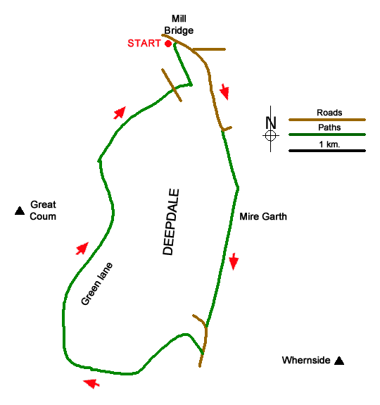
This walk explores Deepdale which lies south of Dentdale between Wnernside and Great Coum. The route follows paths and tracks up the dale to nearly reach the head of the dale. A short section of road walking leads to Occupation Lane which contours the eastern flank of Great Coum before dropping down into the valley to return to the start. Throughout the walk there are excellent views of Deepdale, Dentdale and the surrounding hills.
The start is Mill Bridge which lies a few miles south-east of Dent (grid ref. SD721860) where limited parking is available. Parking can also be obtained further along the lane. After parking, follow the lane south-east. At the next junction keep right and continue up Dyke Hall Lane. After a kilometre of easy uphill walking the lane bends left (grid ref. SD726849). Take the signed path on the right. The path sees few walkers but heads up the valley over stiles to reach Mire Garth. It is useful to have the relevant OS 1:25000 map to help with navigation.
Beyond Mire Garth, the path continues across fields to reach Deepdale Head Farm (grid ref. SD726833). Maintain direction up the valley with the path becoming less obvious as the ground steepens. After a steep section over grass the path exits onto a lane (grid ref. SD724826). Cross the stile and bear left uphill. After 300 metres up the road, turn right onto a clear track (Occupation Road). After an initial ascent the track levels before starting a gradual descent across the side of Great Coum. After 4.3 km. from the road, you reach a junction (grid ref. SD711846).
Turn right and descend more steeply down Nun House Outrake (track) to reach the valley road at Peacock Hill Farm. Cross the road and take the signed footpath opposite, which drops down to farm buildings at Scow (grid ref. SD722855). Just past the buildings the path heads left, crosses a number of fields and reaches a path junction (grid ref. SD720859). Turn right and continue back to the start at Mill Bridge.
Messaging & Social Media
Message Walking Britain and follow the latest news.

Mountain Weather
Stay safe on the mountains with detailed weather forecasts - for iOS devices or for Android devices.