Loch Lee & Falls of Unich
Cairngorms Walk
Nat Park - Cairngorms - Cairngorm South
County/Area - Angus
Author - Lou Johnson
Length - 10.7 miles / 17.4 km Ascent - 1800 feet / 545 metres
Time - 7 hours 10 minutes Grade - mod/hard
Maps 

| Ordnance Survey Explorer OL53 | Sheet Map | 1:25k | BUY |
| Anquet OS Explorer OL53 | Digital Map | 1:25k | BUY |
| Ordnance Survey Explorer OL54 | Sheet Map | 1:25k | BUY |
| Anquet OS Explorer OL54 | Digital Map | 1:25k | BUY |
Walk Route Description
Click image to see photo description.
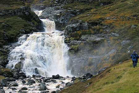
An excellent walk in the South-eastern part of the Cairngorms National Park along the shores of Loch Lee and into the hills beyond. The route climbs to pass the spectacular Falls of Unich and the Falls of Damff higher upstream. The walk includes the Invermark Castle, woodland and some tough walking on the higher ground.
The start is the free car park at Invermark (grid ref. NO446804). Exit the car park and turn right (west) soon passing Lochlee Parish Church on your right. Follow the road ahead to cross Water of Mark and the end of the public road. Continue ahead past the post box and the remains of Invermark Castle on your left. The tarmac continues for 600 metres and then becomes a gravel track. Loch Eel soon appears ahead and the shoreline is followed for two kilometres to the end of the loch (grid ref. NO4121796). Keep ahead at the junction which the walk will return later in the route.
Continue along the clear track up Glen Lee. After just under two kilometres veer left off the track to a footbridge over Water of Lee (grid ref. NO395804). A clear path (rough in places) led sweat with Water of Unich on your left and continue to the Falls of Unich (grid ref. NO387802). Especially after heavy rain, the falls are spectacular. The path the climbs steeply and continues up to the Falls of Damff (grid ref. NO386791). Beyond these falls the gradient eases. Cross the footbridge and continue beside Water of Unich ( on your right) for about 800 metres of rough and often wet path to reach a rough track (grid ref. NO380784).
Turn left up the track which climbs steadily across the moor to pass just south of Cairn Lick (682 m.). One over the crest the track down the Shank of Inchgrundle from where the views to left include Cairn Maskeldie (687 m.) and down to Carlochy which is surrounded by impressive crags. The final section of track a series of zigzags to reach level terrain by Inchgrundle farm. Stay ahead on the track, cross the bridge over Water of Lee and turn right at the junction. Retrace your steps along the track and road back to the start at Invermark.
Other walks nearby
| Walk 2356 | The Cairnwell ridge from Glenshee Ski Centre | mod/hard | 9.3 miles |
| Walk 3108 | Creag Choinnich circular | easy/mod | 4.0 miles |
| Walk 2706 | Morrone (Morven) | moderate | 7.4 miles |
| Walk 1864 | Glen Quoich & Glen Lui (near Braemar) | moderate | 10.0 miles |
| Walk 1119 | Ben Macdui & Carn a' Mhaim | hard | 19.0 miles |
| Walk 1771 | Ladder Hills Circular | mod/hard | 9.5 miles |
| Walk 3081 | Bennachie and Mither Tap | moderate | 6.0 miles |
| Walk 3754 | Ben Vrackie & Meall an Daimh from Pitlochry | mod/hard | 8.0 miles |
| Walk 1777 | Carn Daimh from Glenlivet | moderate | 8.5 miles |
| Walk 1881 | Ben Macdui & Cairn Lochan from the Ski Centre | hard | 10.4 miles |
Recommended Books & eBooks
Great Mountain Days in Scotland
 Inspirational guidebook to 50 challenging routes for mountaineers, scramblers, hillwalkers and fell runners, many long enough to backpack over 2 days, especially in winter (12 to 25 miles). A mix of classic routes and unsung gems across Scotland from Galloway to the Outer Hebrides in widely differing wild landscapes. With customised OS mapping.
More information
Messaging & Social Media
Message Walking Britain and follow the latest news.

Mountain Weather
Stay safe on the mountains with detailed weather forecasts - for iOS devices or for Android devices.