Walk 2184 - printer friendly version
Ebbor Gorge from Wookey Hole Walk
Author - Lou Johnson
Length - 3.0 miles / 4.9 km
Ascent - 600 feet / 182 metres
Grade - easy/mod
Start - OS grid reference ST532476
Lat 51.2256620 + Long -2.6715776
Postcode BA5 1BY (approx. location only)
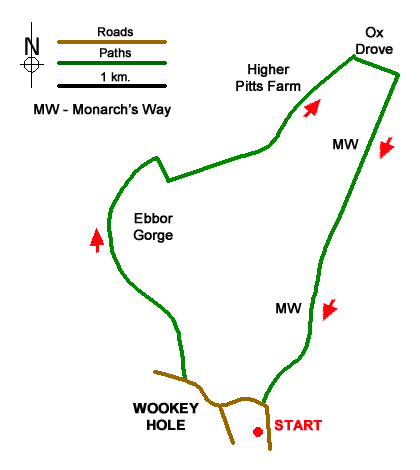
A short walk from Wookey Hole exploring the Ebbor Gorge and surrounding countryside. The Ebbor Gorge is a deep cleft in the limestone of the Mendip Hills amidst woodland. The route involves a climb up the narrow northern end of the gorge. From the top there are excellent views. The walk continues onto higher ground before returning to Wookey Hole down the Monarch's Way.
The walk starts on High Street in Wookey Hole near St Mary Magdalene parish church where limited on street parking is available (grid ref. ST532476). Patrons can also use the parking at the Wookey Hole Inn. However, please ask before parking. To start the walk, continue north along High Street with the church on your right. Follow High Street as it bends left and continue away from the village centre. Reaching a bungalow on the right (grid ref. ST529478) turn right through metal gates to join the West Mendip Way (no signage by the gate). Ignore the path on the right just after the gates and continue on a grassy track with a hedge on your left eft into woodland. You are now in the Ebbor Gorge National Nature Reserve.
Where the West Mendip Way turns right (grid ref. ST526483), continue ahead into the gorge. As you make progress into the gorge you pass between limestone cliffs. There is one section climbing a rocky path which needs care. Continue on the path climbing out of the gorge and bear right with an excellent view on your right. Reaching the West Mendip Way, turn left and follow the path into open countryside and the top of the climb.
Continue along the West Mendip Way passing Higher Pitts Farm on your immediate right to walk along a track. 150 metres beyond the farm the access track bends left to join Dursdon Drove (grid ref. ST536492). Turn right and after 200 metres turn right at the next junction (grid ref ST538492), turn right to join the Monarch's Way. The path descends across pastures along the right-hand side of the fields. The path steepens to drop down the Mendip escarpment and continues to High Street in Wookey Hole.
Messaging & Social Media
Message Walking Britain and follow the latest news.

Mountain Weather
Stay safe on the mountains with detailed weather forecasts - for iOS devices or for Android devices.