Walk 2192 - printer friendly version
Wye Valley Walk Walk
Author - Lou Johnson
Length - 6.6 miles / 10.7 km
Ascent - 950 feet / 288 metres
Grade - easy/mod
Start - OS grid reference SO578340
Lat 52.0028240 + Long -2.6161415
Postcode HR1 4PR (approx. location only)
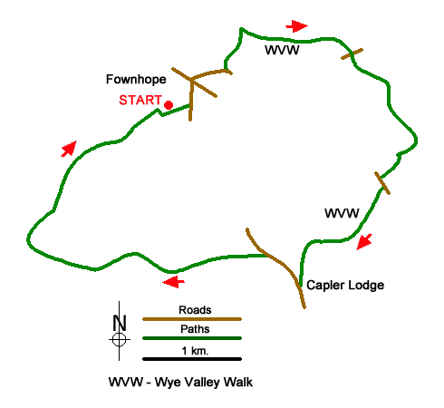
Starting from Fownhope on the east bank of the River Wye this circular walk uses an undulating section of the waymarked Wye Valley Walk (WVW) to reach the viewpoint at Capler Lodge. The route then drops down and follows a path beside the River Wye back to the start. Note that the Wye is liable to flooding after heavy rain and the riverside may be impassable.
The start is the recreation field on the west side of Capler Lane in Fownhope (grid ref. SO578340). After parking exit to the road and turn left passing the cemetery and Church, both on your right. Reaching the 4224 go straight across into Common Hill Lane. Continue up the lane for 350 metres and take the signed footpath on the left, just to the left of a metal farm gate (grid ref. SO584345). The path heads half-right across the field to a hedge corner. Bear right and continue up the field with the hedge on your right.
Cross a track and lane and the walk half-left to enter woodland. Follow the yellow waymarks left, then fork right to reach the Wye Valley Walk after 200 metres. Turn right and continue along the waymarked trail to reach a five-way junction of tracks/lanes (grid ref. SO590348). Go straight across the junction following the WVW waymarks and continue to reach a lane at Common Hill (grid ref. SO595346). Cross the lane slightly right to continue along the WVW. The route continues through Paget's Wood and Lea Wood and exits into open countryside. Pass Overdine on your left and continue to the B4224 (grid ref. SO598334).
Turn left along the B4424 and then turn right to Caplor Farm. Once past the farm, the path continues along the south side of the earthworks of Capler Camp hillfort, before turning south to reach a road at Capler Lodge (grid ref. SO591324). The viewpoint marked on OS maps has suffered from too much vegetation but still offers a worthwhile view the Wye Valley.
Turn right down the lane and continue to the bottom of the hill. Turn left at the fingerpost and then almost immediately take the path on the right which leads to the path beside the River Wye. Continue upstream (with the river on your left). At Mancell's Ferry the path does cross the garden. Continue along the river to reach woodland (grid ref. SO572338) where the path turns inland and skirts the edge of the wood (on your left) before regaining the riverbank at Lea Brink. Just after re-joining the riverside path, turn half-right along the edge of a field (with hedge on your right). After 250 metres pass through a gap in the hedge to return to the recreation filed in Fownhope.
Messaging & Social Media
Message Walking Britain and follow the latest news.

Mountain Weather
Stay safe on the mountains with detailed weather forecasts - for iOS devices or for Android devices.