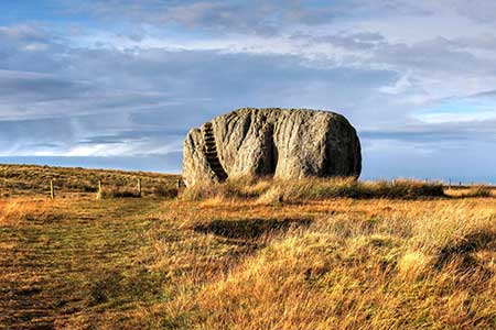
Great Stone of Fourstones from High Bantham
Forest of Bowland Walk
Region - Forest of Bowland
County/Area - North Yorkshire - Skipton
Author - Lou Johnson
Length - 6.7 miles / 10.9 km Ascent - 720 feet / 218 metres
Time - 4 hours 0 minutes Grade - easy/mod
Maps 

| Ordnance Survey Explorer OL2 | Sheet Map | 1:25k | BUY |
| Anquet OS Explorer OL2 | Digital Map | 1:25k | BUY |
| Ordnance Survey Explorer OL41 | Sheet Map | 1:25k | BUY |
| Anquet OS Explorer OL41 | Digital Map | 1:25k | BUY |
Walk Route Description
Click image to see photo description.
Starting from High Bentham this walk visits the Great Stone of Fourstones. A huge gritstone erratic from the Ice Age, it lies on the Lancashire/North Yorkshire border, and it is thought to be the sole survivor of four such stones. Steps have been carved into the side to allow access on the top. The route crosses countryside and includes a short section beside the River Wenning.
The start of the walk is High Bentham (grid ref SD668692) where on street parking is available on Station Road. After parking walk south along Station Road, cross the railway and the River Wenning. Once across the river, turn right along a tarmac driveway. Where the drive forks, keep left and pass between some buildings at Moulterbeck. Go through a gate and follow the path to a stile which leads into woodland. Exit the trees and continue across a field to a stile. Turn left onto a track (grid ref. SD666682). Stay on the track across a field with views to Ingleborough on your left. At the end of the field the path maintains direction across several fields to Bowker House Farm. Pass through the yad and follow the access track to lane.
Cross the lane to the footpath opposite to the signed path. Bear half-left up the field and maintain direction up to Flannagill (grid ref. SD667672). Cross a stile by the house, turn right to another stile. Cross this and enter grassy moorland of Bents. Once across this stile head up a grassy path aiming for the Great Stone of Fourstones. Cross two farm access tracks to reach the Great Stone. The steps carved in the stone provide an easy way to the top. The view from the top is outstanding and includes a large slice of Three Peaks Country.
To continue follow the path back to the first farm access drive and turn right to reach the Slaidburn Road (grid ref. SD672668). Turn left and continue for 300 metres and then head right along a track. At the end of the track, cross the bridge on your right and follow the path across moorland to another track and a wall. Bear right Stay on the track until it bends right at Gruskham. Take the gate at the side of the house and head half left across a field to another gate. Turn right and follow the wall on your right to cross Gill Beck. Cross the slab bridge to a stile in the next wall. Continue to cross the drive to Crow Trees and take the gate opposite. The path maintains direction across four fields to reach a track (grid ref. SD691672). Turn left and follow the track through Stonegrove Farm and onto Mewith Lane.
Turn left and then first right into Brow Lane. Cross the railway and river. Just past the river bridge, turn left over a stile and cross a field aiming for a stile behind the second solitary tree. Bear half ri8ght to a gap in the wooded bank. Bear left and follow the path, with the woodland on your left across three fields. Entering the fourth field slant half-right to a wall stile (grid ref. SD683687). Continue to a track and bear left to reach Ridding Lane Farm. Cross the farm access drive, pass to the right of some large barns and enter a field. Bear half right and follow the path across two fields to reach a house (grid ref. SD677690). Bear left keeping the house on your right. Cross a small field to a stile in the hedge. Turn left along a track for 150 metres and turn left through a gate. Immediately turn right and follow the path with hedge on your right to cross the railway. Once across the railway, turn right and follow a path aiming for the church ahead. Keep to the left of the church and continue to Station Road. Turn right to return to High Bentham.
Other walks nearby
| Walk 3091 | Ingleton Waterfalls Walk | easy | 4.3 miles |
| Walk 3584 | Gragareth from Ireby | moderate | 7.4 miles |
| Walk 1248 | Trow Gill, Ingleborough & Long Scar | moderate | 9.5 miles |
| Walk 2796 | Ingleborough via Gaping Gill & Norber | moderate | 13.0 miles |
| Walk 3599 | Clapham, Oxenber Woods, Feizor & Settle | easy/mod | 7.5 miles |
| Walk 3094 | Norber & Norber Erractics | easy/mod | 6.3 miles |
| Walk 2376 | Gragareth from Leck | moderate | 9.3 miles |
| Walk 1251 | The Norber Erratics & Sulber Gate | moderate | 8.0 miles |
| Walk 2620 | Sulber Gate & Crummack Dale from Austwick | moderate | 9.5 miles |
| Walk 2372 | Lune Valley from Kirkby Lonsdale | easy | 6.1 miles |
Recommended Books & eBooks
Walking in the Forest of Bowland and Pendle
 A guidebook to 40 diverse circular day walks suitable for walkers with navigational skills. The Forest of Bowland and Pendle are two of north west England's upland AONBs, perfect for walkers who enjoy exploring rough hilly, sometimes pathless terrain. The routes include Ward's Stone, Pendle Hill, Longridge Fell and Fair Snape Fell.
More information
Trail and Fell Running in the Yorkshire Dales
 Guidebook to 40 of the best trail and fell runs in the Yorkshire Dales National Park. Ranging from 5 to 24 miles, the graded runs start from bases such as Ribblehead, Dent, Sedbergh, Malham and Grassington and take in the region's diverse delights, from castles and waterfalls to iconic mountains such as Whernside, Ingleborough and Pen Y Ghent.
More information
Messaging & Social Media
Message Walking Britain and follow the latest news.

Mountain Weather
Stay safe on the mountains with detailed weather forecasts - for iOS devices or for Android devices.