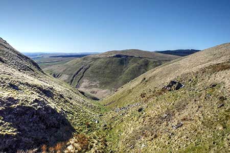
Annandale Way from Devil's Beef Tub
Dumfries and Galloway Walk
County/Area - Dumfries and Galloway
Author - Lou Johnson
Length - 9.0 miles / 14.6 km Ascent - 1500 feet / 455 metres
Time - 6 hours 0 minutes Grade - moderate
Maps 

| Ordnance Survey Explorer 330 | Sheet Map | 1:25k | BUY |
| Anquet OS Explorer 330 | Digital Map | 1:25k | BUY |
Walk Route Description
Click image to see photo description.
Starting from the Devil's Beef Tub on the A701 north of Moffat at the head of Annandale, this excellent walk follows a section of the Annandale Way. The route crosses Annanhead Hill, Great Hill and continues over Chalk Rig Edge before descending into the valley at Ericstane. A section of road walking leads down the valley before the route heads up the side of the valley to cross Ericstane Hill to reach the start. The relevant OS Explorer is a useful addition to your pack.
The start is the layby on the A701 overlooking the Devil's Beef tub (grid ref. NT057126). After parking walk uphill and turn left through a metal forestry gate by a broken finger post. You are now following the Annandale Way which will be used for the full length of the walk. Once through the gate bear right through a smaller gate and follow the grassy path uphill with the fence on your left. A short, steady climb leads to the OS trig column on Annanhead Hill from where a view of most of the route can be enjoyed. Continue east along the ridge to reach a deep cleft (Strait Step). Once across the stream bear half right away from the broken wall and continue to the summit of Great Hill (grid ref. NT068132).
Continue in an easterly direction over Chalk Rig Edge (the highest point of the route) and descend to a cairn (NT084138). Turn right down the Annandale Way descending beside Tweed Hopeburn (on your right). Reaching a planation, the path bears left, and swings southwest to pass to the right of the next plantation. Continue to reach the valley track (grid ref. NT072118). Turn left along the track and continue down the valley to Ericstane Farm. Continue past the farm to join the Old Edinburgh Road. This quiet lane is followed for 2.5 kilometres.450 metres beyond Howslack Farm, turn left over a stone bridge over the River Annan.
After 500 metres from the bridge, you near Meikleholmside Farm. Bear left through a get (signed Annandale Way) to join a green track. The path follows a fence or wall (on your right) climbing steadily up the side of the valley with a glorious view across the valley to the fells just visited. Continue up the track to reach the A701. Cross the road and head through the gate opposite. Follow a grassy track which climbs steadily across the western flank of Ericstane Hill and a short descent to the A701. Turn left back to the start.
Other walks nearby
| Walk 2050 | The Crown of Scotland | moderate | 9.0 miles |
| Walk 2035 | Hart Fell via Hartfell Spa | moderate | 7.2 miles |
| Walk 2280 | Hart Fell & Whitehope Heights | moderate | 8.4 miles |
| Walk 2045 | Capel Fell via Sailfoot Law & Broken Back Hill | moderate | 5.8 miles |
| Walk 2008 | Hart Fell via Saddle Yoke & the Black Hope Horseshoe | mod/hard | 8.5 miles |
| Walk 2135 | Camps Reservoir Circular | easy | 5.8 miles |
| Walk 2618 | Broad Law & Megget Stone | moderate | 5.0 miles |
| Walk 2006 | Grey Mare's Tail & White Coomb | mod/hard | 7.2 miles |
| Walk 3612 | Ettrick Hills Horseshoe | mod/hard | 8.0 miles |
| Walk 3759 | St. Mary's Loch Circular | easy/mod | 7.5 miles |
Recommended Books & eBooks
No suggestions for this area.Messaging & Social Media
Message Walking Britain and follow the latest news.

Mountain Weather
Stay safe on the mountains with detailed weather forecasts - for iOS devices or for Android devices.