Salcombe Regis & Weston Mouth
Jurassic Coast Walk
Region - Jurassic Coast
County/Area - Devon
Author - Lou Johnson
Length - 5.1 miles / 8.3 km Ascent - 1300 feet / 394 metres
Time - 3 hours 50 minutes Grade - easy/mod
Maps 

| Ordnance Survey Explorer 115 | Sheet Map | 1:25k | BUY |
| Anquet OS Explorer 115 | Digital Map | 1:25k | BUY |
Walk Route Description
Click image to see photo description.
Starting from near Sidmouth this walk explores countryside and coast. The route includes the village of Salcombe Regis and its parish church, the Donkey Sanctuary near Weston, and a dramatic section of the South Devon coast following the South West Coast Path. Note there are some steep climbs and descents.
The walk starts from the National Trust Sidmouth Countryside pay and display car park (grid ref. SY139882). After parking, face the rear of the parking area and join the track running along the left-hand side. Just before reaching open countryside, turn left along a path that runs just inside woodland with barns on your right. Go straight ahead at the first two path junctions. At the third junction go straight across to join a descending track through trees. At the bottom, bear left along a track. The track soon joins a lane which is followed into Salcombe Regis. St. Mary and St. Peter's church on the right is worth a visit if time permits.
Just past the church, turn right into the village and take the first lane on the right. The line climbs out of the village. Ignore the first footpath on the left and continue to the next signed path on the left (partly hidden in dense hedge). Follow the grassy path to far-right hand corner of the field and turn right. Keep to the left-hand side of three fields. The path turns left and then almost immediately right and continues to a road (grid ref. SY159892). Turn left and at the mini-roundabout turn right into the Donkey Sanctuary. Walk past the paddocks on your right and keep to the right of the restaurant to a signed path junction. Turn right and follow the path as it descends nearer to the sea at Weston Mouth.
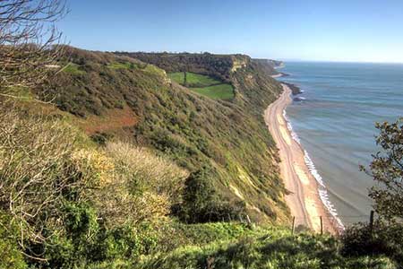
Turn right along the South West Coast Path. The path climbs steeply over Lower Dunscombe Cliff heading inland to walk around the hanging valley of Lincombe. The path returns to the sea and crosses Lower Dunscombe Cliff. Reaching Salcombe Mouth the path briefly turns inland around a deep ravine before continuing close to the cliff top. A final steep climb to the top of the cliffs from where an extensive view can be enjoyed. The path starts to descend. Take the next clear path on the right to return to the car park.
Other walks nearby
| Walk 1636 | Danger Point & Ladram Bay from Otterton | easy/mod | 6.0 miles |
| Walk 1795 | Beer & Branscombe Circular | easy/mod | 5.5 miles |
| Walk 2030 | Budleigh Salterton, East Devon | easy/mod | 7.0 miles |
| Walk 1550 | Charmouth & Lyme Regis Circular | easy/mod | 6.0 miles |
| Walk 2771 | Lyme Regis & Uplyme Circular | easy/mod | 5.5 miles |
| Walk 1551 | Seatown and Charmouth via Golden Cap | easy/mod | 5.0 miles |
| Walk 2580 | Golden Cap & Charmouth | easy/mod | 5.0 miles |
| Walk 1549 | Golden Cap from Seatown | easy/mod | 4.0 miles |
| Walk 2391 | West Bay & Burton Cliff | easy | 4.5 miles |
| Walk 1978 | Blackdown Hills & Castle Neroche | easy/mod | 6.8 miles |
Recommended Books & eBooks
South West Coast Path Map Booklet - St Ives to Plymouth
 Map of part of the southern section of the 630 mile (1014km) South West Coast Path National Trail. Covers the trail from St Ives to Plymouth along the west Cornwall and Devon coastline. This convenient and compact booklet of Ordnance Survey 1:25,000 maps shows the route, providing all of the mapping you need to walk the trail in either direction.
More information
South West Coast Path Map Booklet - Minehead to St Ives
 Map of the northern section of the 630 mile (1014km) South West Coast Path National Trail. Covers the trail from Minehead to St Ives along the north Devon and Cornish coastline. This convenient and compact booklet of Ordnance Survey 1:25,000 maps shows the route, providing all of the mapping you need to walk the trail in either direction.
More information
Messaging & Social Media
Message Walking Britain and follow the latest news.

Mountain Weather
Stay safe on the mountains with detailed weather forecasts - for iOS devices or for Android devices.