Walk 2280 - printer friendly version
Hart Fell & Whitehope Heights Walk
Author - Lou Johnson
Length - 8.4 miles / 13.7 km
Ascent - 2300 feet / 697 metres
Grade - moderate
Start - OS grid reference NT075104
Lat 55.3788280 + Long -3.4613724
Postcode DG10 9LT (approx. location only)
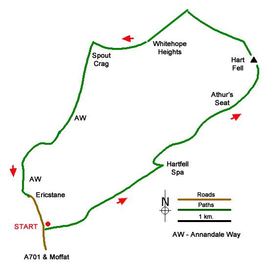
An excellent hill walk to the summits of Hart Fell (808 m.) and Whitehope Heights (637 m.). The route needs careful navigation especially in poor visibility. The start is a small parking area adjacent to the isolated corrugated building of Annan Water Hall (grid ref. NT075104). After parking walk north and turn right onto the footpath signed to Hartfell Spa.
The path crosses fields to reach the Auchencat Burn, which can be followed upstream. but it entails crossing the burn on some rickety wooden footbridges. There is an easier path just to the north and higher up on the flank of Well Rig. Either way continue to Hartfell Spa which is a chalybeate spring contained within a small stone structure. After viewing the structure, retrace your steps downstream and head right up the hillside of Well Rig to a grassy track which is followed over Arthur's Seat until the fence line is reached. If you cross the fence, take care as the cliffs of Hartfell Craig are not far beyond though the view down the Black Hope Glen is worth it on a clear day. Otherwise follow the fence line north-westerly to the summit of Hart Fell.
Leave the summit following the fence north-northeast and descend taking care near a crag to a col, which can be wet underfoot after heavy rain. Continue beside the fence up the steep slope ahead Nearing the top of the climb, veer left and stay with the fence as it leads to the summit of Whitehope Heights (grid ref. NT096139). The descent route continues by the fence, crosses the top of Spout Crag, and drops down to a large cairn (grid ref. NT084138).
Turn left down the Annandale Way descending beside Tweed Hopeburn (on your right). Reaching a planation, the path bears left, and swings southwest to pass to the right of the next plantation. Continue to reach the valley track (grid ref. NT072118). Turn left along the track and continue down the valley to Ericstane Farm. Walk past the farm to join the Old Edinburgh Road. This quiet lane is followed for 700 metres back to the start.
Messaging & Social Media
Message Walking Britain and follow the latest news.

Mountain Weather
Stay safe on the mountains with detailed weather forecasts - for iOS devices or for Android devices.