Walk 2282 - printer friendly version
Bewick Moor Walk
Author - Lou Johnson
Length - 9.1 miles / 14.8 km
Ascent - 1000 feet / 303 metres
Grade - moderate
Start - OS grid reference NU107195
Lat 55.4692180 + Long -1.8323085
Postcode NE66 2TX (approx. location only)
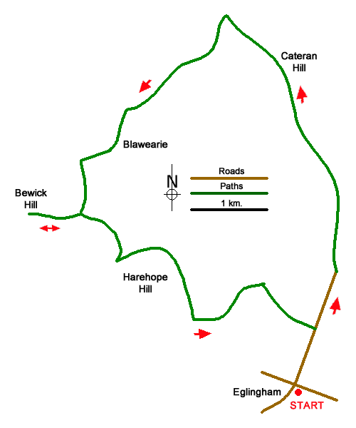
Starting from Eglingham this walk explores some of the highlights of the southern part of Bewick Moor. The route needs careful navigation in places but generally follows clear paths and tracks. The walk visits the highest point of the moor at Cateran Hill (267 m.), nearby Cateran Hole, passes the ruined farm of Blawearie, and Bewick hill the site of a hillfort and cup and ring marked rocks.
The start is the village of Eglingham on the B6346 where limited on road parking is possible opposite the Tankerville Arms (grid ref. NU107195). After parking and facing the Tankerville Arms, walk right and after 150 metres turn right along a lane (signed as a no through road). Initially tarmac, the lane climbs steadily out of the valley and after 1400 metres reaches a gate at the edge of the moor. Pass through the gate and follow the clear track across the moor to gate and adjacent cattle grid (grid ref. NU111217).
Pass through the gate and bear left off the track to join a grassy path which heads north. The path continues ahead and passes Hare Crag (a series of rocks on your left) to a path junction (grid ref. NU110222). Turn left and then after 60 metres turn right to join a grassy track. Stay on the track and continue north. Pass through a gate and continue to Cateran Hill. Take time to enjoy the view which includes the Cheviot Hills, the Farne Islands, and the coast.
Lave the summit and continue northwest. After 400 metres a short diversion along a narrow path on the right takes you to Cateran Hole. This cleft in the sandstone can be explored by descending the steps into a cave. Exploration complete, return to the main path and turn right to reach a clear track (grid ref. NU098239). Turn left and follow the track for just over two kilometres to the ruins of Blawearie Farm. Keep the ruins on your left and continue along the track heading west. 500 metres beyond the farm (before reaching a gate ahead), bear left of the track along a grassy track. You soon reach a wall corner on your right (grid ref. NU080218). Bear right off the track and follow a path beside the wall (on your right). Continue ahead to a fence.
Turn right through a gate to explore Bewick Hill with its cup and rings marked stones and the remains of the hillfort. After completion of your exploration return to the gate and walk ahead with the fence on your right. Stay with the fence over Tick Law and descend into a dip (with Harehope Hill ahead). Turn left to follow another fence (on your right). Turn right through a gate and join a clear track and continue to another gate before Harehope Farm (grid tef. NU094203). Pass through the gate and turn right.
Walk past the first buildings on your left and turn left. Continue through two gates into a field where you keep to the right. Join a clear track, cross Harehope Burn and continue to a fork in the track after 200 metres. Fork right onto the lesser track and continue to you are level with the corner of a plantation on your left (grid ref. NU101207). Fork right and pass through a gate to follow a bridleway initially heading southeast. The track soon becomes clearer, and swings left. Continue on the track to reach the lane used at the start of the walk. Turn right and return to Eglingham.
Messaging & Social Media
Message Walking Britain and follow the latest news.

Mountain Weather
Stay safe on the mountains with detailed weather forecasts - for iOS devices or for Android devices.