Walk 2337 - printer friendly version
Greenlee Lough and Steel Rigg Walk
Author - Lou Johnson
Length - 7.5 miles / 12.2 km
Ascent - 850 feet / 258 metres
Grade - easy/mod
Start - OS grid reference NY750676
Lat 55.002336Ā + Long -2.3923620
Postcode NE47 7AW (approx. location only)
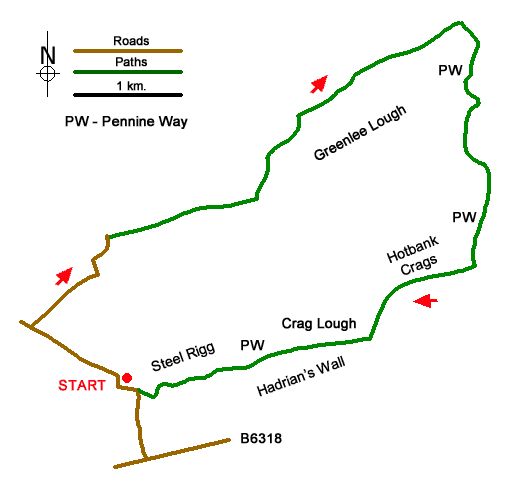
Starting from Steel Rigg this walk explores a section of Hadrian's Wall and countryside to the north of the wall including picturesque Greenlee Lough. The route follows a quiet country lane before heading across open farmland to pass Greenlee Lough. The walk then joins the Pennine way and heads south to Hadrian's Wall at Hotbank Crags. The undulating path then follows the wall passing Crag Lough, before heading across a line of crags back to the start.
The walk starts from the Steel Rigg car park (grid ref. NY750676) which lies to the north of the B6138. After parking, return to the lane and turn right. Follow the lane for 800 metres to a junction and turn right (signed Gibbs Hill). After a straight section, the lane bends left, then right and then veers left after which turn right onto a signed footpath (grid ref. NY750689). Pass through the kissing gate and cross open country. Eventually the path runs to the left of a plantation before heading left to cross a footbridge over Caw Burn. After a section of boardwalk, the path bears right and runs parallel to the shore of Greenlee Lough - a National Nature Reserve. After a section of plantation on the right you can divert right to the lough for a closer look at this beautiful stretch of water. Return to the main path and turn right.
At a three-way fingerpost (grid ref. NY770701) continue ahead to pass through West Stonefield. Continue along a track, with a wall on your right, to East Stonefield. Climb the ladder stile and continue through the yard and along the track passing the house on your left. Where the track veers left, keep close to the wall on your right and continue to a gate with adjacent ladder stile (grid ref. NY780707). Turn right here to join the Pennine Way. The waymarked path is generally easy to follow and can get wet in places after rain. After a steep pull up to Hadrian's Wall just east of Hotbank Crags, turn right and follow a well-used path along the remains of the wall. The Hadrian's Wall Path has combined with the Pennine Way for the remainder of the walk. Continue across the top of Hotbank Crags, pass above beautifully situated Crag Lough, and continue back to the start at Steel Rigg.
Messaging & Social Media
Message Walking Britain and follow the latest news.

Mountain Weather
Stay safe on the mountains with detailed weather forecasts - for iOS devices or for Android devices.