Walk 2350 - printer friendly version
Appuldurcombe Circular Walk
Author - Lou Johnson
Length - 5.5 miles / 8.9 km
Ascent - 900 feet / 273 metres
Grade - easy/mod
Start - OS grid reference SZ530817
Lat 50.6325950 + Long -1.2519692
Postcode PO38 3JD (approx. location only)
This varied walk starts from Godshill and explores the countryside south of the village. The route includes varied landscapes including downs, woodland, and pastures. Perhaps the highlight of the walk are the ruins of Appuldurcombe House and the surrounding parkland. The highest point of the route on Appuldurcombe Down offers fine views including the coast.
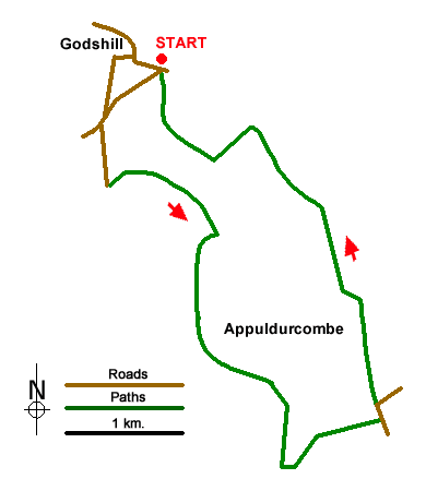
The walk starts from Godshill car park (grid ref. SZ530817) on the north side of the A3020 to the east of the village centre. After parking, exit the car park and turn right along High Street towards the centre of the village. Continue past the Model Village on your left and turn left along Church Hollow in front of thatched cottage/shop. Continue uphill to a T-junction and turn left up Church Hill. Continue ahead at the first junction and fork left at the next into Sheepwash Lane. Continue past the entrance to Sainham Farm. 200 metres beyond the farm entrance, turn sharp left onto a signed bridleway (grid ref. SZ5626809).
The bridleway passes through woodland to reach a fork after 250 metres. Keep right here and follow the bridleway, initially between hedges, to a barn. Just past the barn the path heads half right and continues across a field and through woodland to reach a path junction (grid ref. SZ534805) at Gat Cliff. Turn right along the signed bridleway to Stenbury Down. At first the route runs below the western slopes of Appuldurcombe Down but soon climbs steeply up to the radio station service track. Turn right down the track (signed Stenbury Down) enjoying views to the coast as you descend.
Continue past a second radio station (on your left) and continue along the track at it bends left and continue to Rew Lane (grid ref. SZ545792). Turn left and where the lane bends right continue ahead along a track (with adjacent footpath sign). Pass Span Lodge Farm on your right and continue ahead across fields to reach Appuldurcombe House which is surrounded by trees. Continue along the edge of the site and follow the path as it curves left to reach Appuldurcombe Road with the Coach House on your left (grid ref. SZ543801). Take the gravel track (signed footpath) which runs north, with the car park on your immediate right.
Where the track bends left to Appuldurcombe Farm, continue ahead along a grassy track to Fremantle Gate. Continue ahead following the Stenbury Trail, initially through woodland and then across open countryside. Entering trees again, a footpath comes in from the right (grid ref. SZ537812). 100 metres beyond this junction turn left onto a signed bridleway which after 300 metres enters woodland and turns right. The bridleway curves left to reach a signed footpath on the right. Take this path and continue through woodland to return to Godshill car park used at the start of the walk.
Messaging & Social Media
Message Walking Britain and follow the latest news.

Mountain Weather
Stay safe on the mountains with detailed weather forecasts - for iOS devices or for Android devices.