Walk 2354 - printer friendly version
Merry Maidens & Lamorna Cove Walk
Author - Lou Johnson
Length - 4.1 miles / 6.7 km
Ascent - 550 feet / 167 metres
Grade - easy
Start - OS grid reference SW432245
Lat 50.0650460 + Long -5.5897283
Postcode TR19 6BQ (approx. location only)
An interesting walk featuring the Merry Maidens standing stones, Lamorna Cove and a section of rugged coastline following the South West Coast Path. The Merry Maidens are one of the best-preserved stone circles in the British Isles and date from 2500 BC.
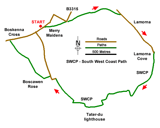
The walk starts from the small parking area on the south side of the B3315 that is adjacent to the entrance to the Merry Maidens (grid ref. SW432245). Exit the parking area through a gate to reach the stone circle. After inspecting this fine prehistoric monument, continue across the field to cross a stile. Then walk half left across the next field to a gate by a telegraph pole and exit onto the B3315. Bear right down a signed no-through road. After 400 metres the lane forks. Cork left and follow a bridleway downhill into the Lamorna Valley. Reaching a lane, turn right and follow the lane through Lamorna village. Keep ahead and you will soon pass the Lamorna Wink on your left. The lane then leads you through a beautiful, wooded valley to Lamorna Cove.
Just before the car park, bear right in front of a row of cottages (signed Coast Path to Penberthy). The undulating path initially runs close to the cliff tops on your left. The first landmark is Carn Barges, which is reached after climbing a stepped section of path. This large standing stone is perched above the sea. From here the path turns inland climbing high above the sea. After a short descent through a patchwork of small fields (used for growing flowers) you reach Tater-fu Lighthouse. Beyond the lighthouse the route follows a clear track which forks right inland just after passing a farm up on your right (grid ref. SW436232).
Leave the Coast Path here and follow the track uphill inland. Continue up the track to Tregiffian Farm where you join a tarmac lane. Follow the lane as it bends left and then right. Just after the bend, turn right over a stone stile in the hedge or go through the adjacent gate. Note there is no footpath sign here. Follow the left-hand edge of the field and exit the field by another stile onto a track (grid ref. SW432236). Turn right and continue to Boscawen Rose Farm. Pass between the farmhouse on your right and farm buildings on your left. Just past the farmhouse, turn left and between barns. At the end of the barns veer half left to enter a field. Continue along the right-hand side of this field. Nearing the end of the filed, head half left across the field to a stile in the field corner (grid ref. SW429240).
After crossing the stile continue with hedge on your left. The next field on your left contains a large solitary standing stone, which is aligned with the Merry Maidens. Continue to a sile and into the next field. Head slightly right to another stile in the hedge opposite. Entering the final field, maintain direction across the field to follow the path beside the left-hand hedge. Cross a stile onto the B3315. On your left is the Boskenna Cross. These crosses were used to mark routes across the countryside. Turn right along the road, passing Tregiffian Barrow on your right, and return to the car park by the Merry Maidens. If time permits, cross the road to a stile opposite. The path leads to a massive standing stone called Gun Rith.
Messaging & Social Media
Message Walking Britain and follow the latest news.

Mountain Weather
Stay safe on the mountains with detailed weather forecasts - for iOS devices or for Android devices.