Walk 2364 - printer friendly version
Clough Head via Great Dodd from near Dockray Walk
Author - Lou Johnson
Length - 8.1 miles / 13.2 km
Ascent - 2000 feet / 606 metres
Grade - moderate
Start - OS grid reference NY380219
Lat 54.5884720 + Long -2.9609330
Postcode CA11 0LG (approx. location only)
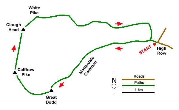
Clough Head is the most northerly summit on a long ridge of hills stretching north from Ambleside and offers an excellent panorama across the Lake District Fells. The route starts from above Dockray and crosses Matterdale Common to Great Dodd. From here the walk continues over Calfhow Pike to Clough Head's summit. The descent route joins the Old Coach Road for an easy return to the start.
The start is the parking area at High Row (grid ref. NY380219) above Dockray. After parking, take the unsigned track (The Old Coach Road), pass through a gate, and continue with a plantation on your right to where the track bends sharp right. Cross Grove Beck and turn left onto a rising path with Grove Beck below on your left. The path steadily across open fell soon reaching Matterdale Common which is crossed in a south-westerly direction with the slopes of Great Dodd rising ahead. After passing the rocky knoll of Randerside, the gradient steepens to reach the summit of Great Dodd with its small cairn (grid ref. NY342206). Take time to enjoy the extensive view across Lakeland.
Initially descend to the west along a path which soon swings north-west and descends to the rocky outcrop of Calfhow Pike. After a short descent the path climbs easily to reach Clough Head with its OS trig column and a rudimentary stone windbreak. The view to Blencathra is particularly noteworthy. To start the descent, follow the clear path heading northeast. After 500 metres your reach the rocks of White Pike (grid ref. NY339229) which is worth a few minutes climb to enjoy the view. Just before reaching the rocks, you reach a cross path. To continue the descent, turn right and descend steeply at first on a mostly clear path heading east towards the Old Coach Road. Which is clearly visible ahead in fine weather.
Reaching the track (grid ref. NY348230), turn right and continue for about four kilometres of easy level walking back to the start.
Messaging & Social Media
Message Walking Britain and follow the latest news.

Mountain Weather
Stay safe on the mountains with detailed weather forecasts - for iOS devices or for Android devices.