Walk 2372 - printer friendly version
Lune Valley from Kirkby Lonsdale Walk
Author - Lou Johnson
Length - 6.1 miles / 9.9 km
Ascent - 350 feet / 106 metres
Grade - easy
Start - OS grid reference SD616782
Lat 54.1981080 + Long -2.5900985
Postcode LA6 2FJ (approx. location only)
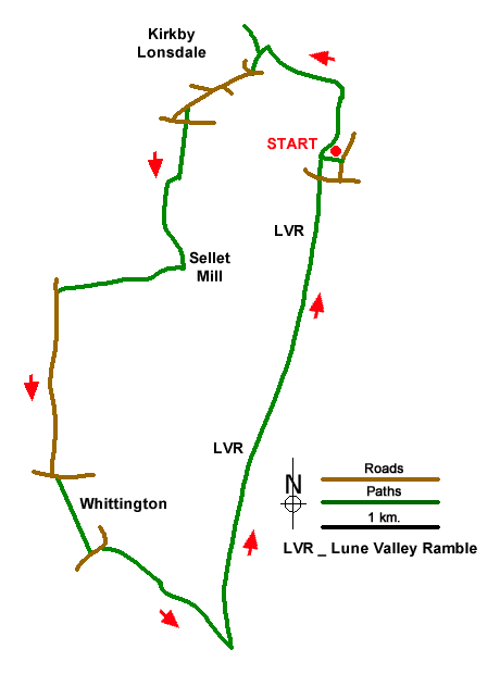
Starting from the interesting market town of Kirkby Lonsdale, this circular walk explores the countryside and Lune Valley lying to the south of the town. The route follows signed paths, a quiet lane, and a section of the Lune Vally Ramble. In Kirkby Lonsdale you can enjoy Ruskin's View, Devil's Bridge and, if time permits, visit St. Mary's Church.
The start is Devil's Bridge (grid ref. SD616782) where several parking options are available. After parking walk to the bridge and descend to the clear path and walk north with the River Lune on your right. Follow the riverside path as it sweeps left to pass The Island midstream. Turn left up the Radical Steps. At the top of the steps turn right and walk a short way to enjoy Ruskin's View. Return to the steps and turn right across the churchyard keeping St. Mary's on your immediate left. Exit the churchyard and walk along narrow Church Street opposite. Turn right into Market Street and then fork left up Mitchelgate. Continue to the B6446 and fork right uphill. Continue a short distance and then fork left along Biggins Road. Reaching tennis courts on the left, turn left onto a signed footpath and continue to the A65 (grid ref. SD607785).
Cross the road with care and join the signed footpath opposite at the top of a flight of steps. The path maintains direction across three fields and then heads half right to a gate and a two-way fingerpost on a lane near Wood End Farm. Turn left and follow a walled lane south for 500 metres to reach a farm near Sellet Mill. Turn right on a signed footpath just before the farm buildings and continue across fields passing Sellet Hall on your left to a stile and a lane (grid ref. SD599774).
Turn left along Hosticle Lane for just over a kilometre to a T-junction in the village of Whittingham. Turn left and then right onto a signed footpath leading into the churchyard of St Michael the Archangel. Pass the church on your left and follow the path down to the lower graveyard. The path runs beside a hedge on your left to a fork in the path. Bear right and follow the path which eventually passes through some trees to exit at a gate onto a road. Turn left and after 100 metres bear right to join a signed bridleway. Follow the track (Burrow Mill Lane) with Low Hall Farm on your left and continue to reach the River Lune. (Note the track bends sharp right and then left before reaching the river).
Turn left along the riverside path to follow the Lune Valley Ramble. Three kilometres of relaxing walking leads under the A65 at Stanley Bridge and shortly after you return to Devil's Bridge in Kirkby Lonsdale.
Messaging & Social Media
Message Walking Britain and follow the latest news.

Mountain Weather
Stay safe on the mountains with detailed weather forecasts - for iOS devices or for Android devices.