Walk 2376 - printer friendly version
Gragareth from Leck Walk
Author - Lou Johnson
Length - 9.3 miles / 15.1 km
Ascent - 1700 feet / 515 metres
Grade - moderate
Start - OS grid reference SD643766
Lat 54.1839240 + Long -2.5485243
Postcode LA6 2JD (approx. location only)
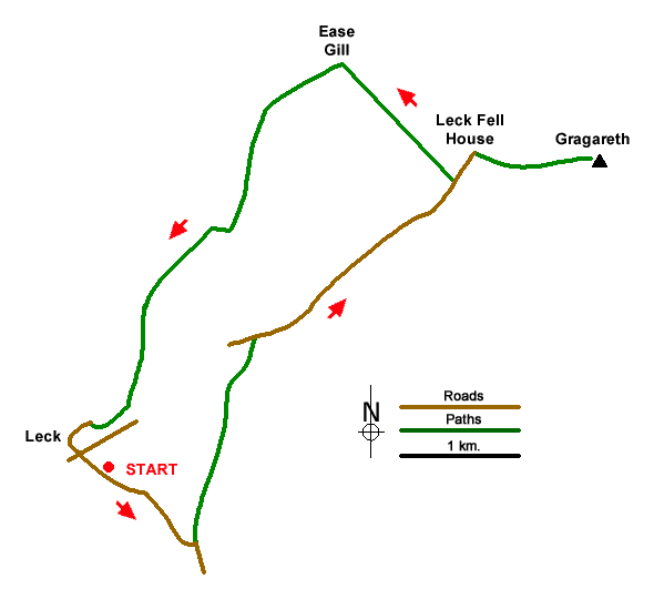
A varied circular walk from Leck explores the area lying north of the village and includes an ascent of Gragareth (627 m.), the highest point in Lancashire. The complete route lies within the boundaries of the Yorkshire Dales National Park, the only part of Lancashire included in this National Park. The walk uses byways, lanes and paths through a rolling landscape and finishes by following Leck Beck through a partly wooded valley.
The start is the small car park adjacent to St Peter's Church at Leck (grid ref. SD643766). A small contribution in the courtesy box is welcome. After parking face the lane and turn left past the front of the church. Continue along the lane for just over a kilometre to a sharp right-hand bend just past Todgill Farm. Turn left up a walled track and continue for two kilometres to a lane (grid ref. SD657776). The lane climbs steadily onto Leck Fell and eventually leads to the end of the lane at lonely Leck Fell Farm. As you approach the farm, fork right onto a gated track. Continue for 250 metres and turn right up the fell, climbing steeply to reach the cairns, the Three Men of Gragareth. The gradient eases beyond the cairn and the summit of Gragarerth is soon reached. Allow time to enjoy the extensive view across the Yorkshire Dales.
Follow the ascent route back down to the track. Turn left, pass through the gate, and join the tarmac lane. Pass through a metal gate and turn right alongside a wall. The next section is almost pathless although there are places where a feint path can be used. Expect some wet ground as you cross the moorland on the flank of Leck Fell. Stay with the wall on your right and continue to reach the valley containing Ease Gill (upper reaches of Leck Beck). Just before reaching the gill, turn left and walk across a shelf above the gill. The gill is dry except after heavy and persistent rain and by dropping down to you right you can visit the dry waterfall.
Turn south and follow an intermittent path with the gill on your right. The interesting geology of Ease Gill Kirk is soon reached and is worth closer inspection. A clear path then leads south with Leck Beck still on your right. Continue south to pass the ruined farm of Anneside (grid ref. SD656788). 200 metres beyond the ruins, turn right over a stile and continue along the path to reach Leck Beck. Turn left and continue south. The path soon leads into a grassy track which passes through a wood before reaching a lane at Leck Mill. Fork left at the first junction and reaching the next junction go straight across to join a track which leads back to the start at Leck Parish Church.
Messaging & Social Media
Message Walking Britain and follow the latest news.

Mountain Weather
Stay safe on the mountains with detailed weather forecasts - for iOS devices or for Android devices.