Walk 2394 - printer friendly version
East Meon & Wether Down Walk
Author - Lou Johnson
Length - 8.0 miles / 13 km
Ascent - 800 feet / 242 metres
Grade - easy/mod
Start - OS grid reference SU678222
Lat 50.9952110 + Long -1.0352619
Postcode GU32 1NN (approx. location only)
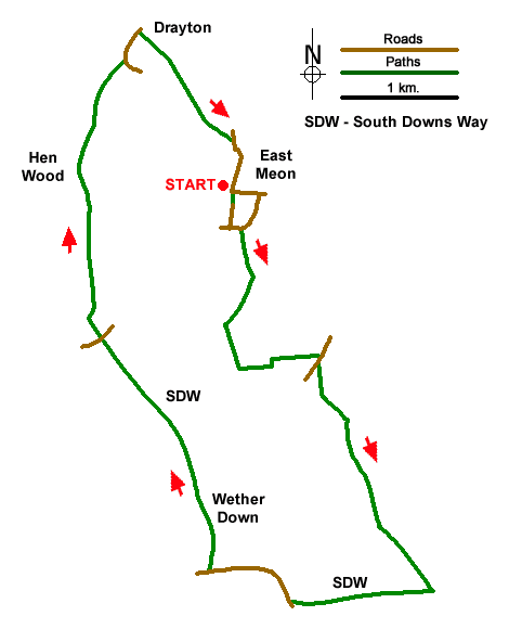
An energetic walk exploring the countryside and downs lying south of East Meon. The route includes the source of the River Meon, a section of the South Downs Way (SDW), Wether Down and Salt Hill. The walk starts from the village hall car park in East Meon (grid ref. SU678222). This car park is signed from the village centre. After parking make your way to the car park entrance and take the signed footpath on the right. Cross the village green to an exit between houses. Bear right and follow Duncombe Road to a T-junction. Turn left and after 120 metres turn left into a parking area (grid ref. SU678219).
At the end of the car park go through a kissing gate to join a path heading south. The path crosses several fields and joins a track running along the left-hand side of a field into a wooded area. Exit the trees and turn left to follow a grassy track across a field with a hedge on your left. At the end, turn left through the hedge and continue with hedge left across another field. Pass through the hedge and turn left to follow the path around the left-hand edge of a field to a road by Lower Farm.
Turn right and then left through kissing gate by adjacent driveway (grid ref. SU684208). Cross the grass, pass through another gate and bear left along drive through South Farm. Continue along the drive across the River Meon near its source. Stay on the driveway which leads into a track. Pass between barns and continue through a gate into a field. The rising path follows the left-hand edge and continues up to the South Downs Way (grid ref. SU693190).
Turn sharp right along the SDW which soon leads to a road. Continue ahead to the road opposite. Where the road forks bear right signed to Droxford. Almost immediately bear left off the road to join the SDW. The path runs roughly parallel to the road, and then leads back to the road. Walk ahead and turn right at the next fingerpost to follow the continuation of the SDW north along a track over Wether Down and Salt Hill. After passing a group of barns the track becomes a path which descends to a road at Coombe Cross. (grid ref. SU667210).
Cross the road and continue along the SDW. The path enters trees, swings right and then left and continues for 450 metres to where the SDW turns left. Continue ahead along Halnaker Lane. for 1.5 kilometres to join a lane which leads to a road (grid ref. SU669232) by Drayton Cottages. Bear left along the road for 200 metres and turn right at the first fingerpost. The path crosses fields to a lane (grid ref. SU667276). Turn right and follow the lane towards East Meon. Reaching a crossroads, go straight across and the car park used at the start of the walk is a short way ahead on the right.
Messaging & Social Media
Message Walking Britain and follow the latest news.

Mountain Weather
Stay safe on the mountains with detailed weather forecasts - for iOS devices or for Android devices.