Ackling Dyke from Sixpenny Handley
Countryside Walk + Roman Road + Ancient Earthworks
County/Area - Dorset
Author - Lou Johnson
Length - 8.6 miles / 14 km Ascent - 530 feet / 161 metres
Time - 4 hours 50 minutes Grade - easy/mod
Maps 

| Ordnance Survey Explorer 118 | Sheet Map | 1:25k | BUY |
| Anquet OS Explorer 118 | Digital Map | 1:25k | BUY |
Walk Route Description
Click image to see photo description.
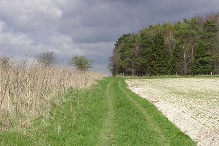
Starting from the Dorset village of Sixpenny Handley this walk explores the chalk downloads to the south and east. The route includes collections of burial mounds from the Neolithic and Bronze Age on Gussage Hill and Bottlebush Down, a section of a Roman Road and crosses the Dorset Cursus a Neolithic earthwork.
The start is the free car park at Recreation Ground at the west of Sixpenny Handley (grid ref ST993174). After parking exit the parking area and turn left along the road into the village. Just past the school on the left, turn right along a narrow lane that runs beside the funeral directors. Follow Bushy Bush lane and pass the farm of the same name. 300 metres beyond the farm fork left along a bridleway between fences. Ignore the footpath on the left and continue a further 400 metres to a cross track (grid ref. ST982160) and turn left to follow the Jubilee Trail. Continue to the A354.
Cross with care to the signed bridleway opposite. The bridleway heads southeast, crosses the Dorset Cursus and cross Gussage Down passing the remains of ancient settlements and long barrows. Cross two tracks and continue to a line of trees. Turn left along a signed bridleway which follows the course of Roman Road or Ackling Dyke. After three kilometres and after crossing a lane, you reach the B3081. Cross the road to the signed path slightly left. Cross the stile and continue along Ackling Dyke for 1.5 kilometres passing tumuli on the left. In places the path is slightly overgrown, but you can use the adjacent field edge to bypass any sections. Continue ahead to pass a garage on the left and turn left along a grassy track back to the A354 (grid ref. SU021177).
Cross the road with care to the bridleway opposite. The path runs along the right-hand edge of a field and soon turns left still following the edge of the field. Nearing some buildings ahead the path becomes a track. Continue to a T-junction. Cross the junction to the continuing bridleway across fields. The path leads to a clear track (Oakley Lane). Bear left and continue to a T-junction. Cross road to stile opposite and follow the path which runs across the fields to reach a camp and caravan site. Walk through the site to join a tarmac lane. At the next junction, turn right and follow the road past the school and back to the car park in Sixpenny Handley.
Other walks nearby
| Walk 3743 | Win Green from Tollard Royal | easy/mod | 5.4 miles |
| Walk 3237 | Bowerchalke & the Ox Drove | easy/mod | 8.0 miles |
| Walk 2171 | Knighton Hill & the Ox Drove | easy/mod | 5.8 miles |
| Walk 3626 | The Fovant Badges from Broad Chalke | easy/mod | 9.3 miles |
| Walk 3679 | Wardour Castle, Ansty Down & Wardour Park | easy/mod | 7.5 miles |
| Walk 3695 | Hambledon Hill & Hod Hill from Shroton | easy/mod | 6.0 miles |
| Walk 2343 | Higher Pertwood & Wessex Ridgeway from Hindon | easy/mod | 8.1 miles |
| Walk 2158 | Great Wishford & Grovely Lodge | easy/mod | 6.6 miles |
| Walk 2666 | North west of the New Forest circular | easy/mod | 9.3 miles |
| Walk 3544 | Frogham and the Hampton Ridge | easy | 3.9 miles |
Recommended Books & eBooks
Walking the Jurassic Coast
 This guidebook includes 30 walks on the Jurassic Coast of Devon and Dorset. Covering the coast between Exmouth and Bournemouth, these delightful routes range from 3 to 16 miles (5 to 24km), exploring and explaining the spectacular geology of this World Heritage area with clear, easily understood descriptions, cross-sections and timelines.
More information
Messaging & Social Media
Message Walking Britain and follow the latest news.

Mountain Weather
Stay safe on the mountains with detailed weather forecasts - for iOS devices or for Android devices.