Walk 2488 - printer friendly version
Shipman Knotts & Kentmere Pike Walk
Author - Lou Johnson
Length - 6.2 miles / 10.1 km
Ascent - 1800 feet / 545 metres
Grade - moderate
Start - OS grid reference NY461041
Lat 54.4294530 + Long -2.8323466
Postcode LA8 9JP (approx. location only)
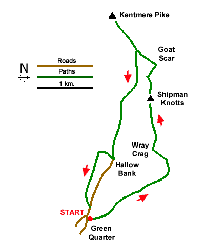
A straightforward ascent of Kentmere Pike that offers excellent walking with superb views. The outward route follows a path over Wray Crag to the summit of Shipman Knotts. The walk continues to reach the minor top above Goat Scar to gain the main ridge which is followed to Kentmere Pike's summit. The return route descends to Hallow Bank from where bridleways and lanes return to the start.
The walk starts from the small community of Green Quarter (grid ref. NY461041) where there is parking space for a few cars. If none are available, then start from Kentmere. From the small village green walk uphill along the no-through road and join the signed path which heads uphill northwest to join the Hallow Bank to Sadgill track (grid ref. NY476050) which lies in a broad col. Cross the track and follow the path steeply uphill with a wall on your right. This path leads over Wray Crag and continues up to the summit of Shipman Knotts.
After a very brief descent continue up to a ladder stile over a wall (grid ref. NY472067). Once over the stile you can either take the main path or my preferred choice is to follow the fence on your right up to the minor top (spot height 629m) and then turn left along the fence and later a wall to the summit of Kentmere Pike. The view is extensive and includes Yoke, Ill Bell etc. across the Kentmere valley. The view also extends east to Harrop Pike and Selside. Looking southwest Windermere can also be seen.
To start the descent, retrace your steps along the approach path. Just before the wall changes to a fence, fork left and follow a grassy path down to a ladder stile (grid ref. NY470069). The path soon swings southwest then heads down a grassy gulley to pass through a gap in a wall (grid ref. NY467061). Continue to descend to reach Hallow Bank. Head downhill along a narrow lane to reach a fingerpost on the right. Turn right down the signed bridleway and approaching houses ahead turn left. Pass a barn on your right and continue along the track as it turns south. You are now on Low Lane (track) which heads south with a wall on your right. After 300 metres the track runs between walls and after 600 metres reaches a tarmac lane. Turn right and continue back to Green Quarter.
Messaging & Social Media
Message Walking Britain and follow the latest news.

Mountain Weather
Stay safe on the mountains with detailed weather forecasts - for iOS devices or for Android devices.