Quainton & North Marston Circular
Pub Walk + Hill Walk + Countryside + Windmill
County/Area - Buckinghamshire - North Buckinghamshire
Author - Lou Johnson
Length - 6.8 miles / 11.1 km Ascent - 550 feet / 167 metres
Time - 4 hours 0 minutes Grade - easy/mod
Maps 

| Ordnance Survey Explorer 192 | Sheet Map | 1:25k | BUY |
| Anquet OS Explorer 192 | Digital Map | 1:25k | BUY |
Walk Route Description
Click image to see photo description.
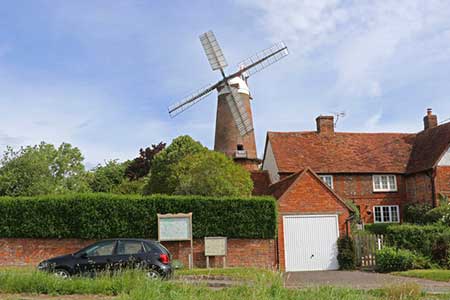
Starting from the north Buckinghamshire village of Quainton this walk explores an area of hills and farmland. The route passes by the preserved windmill in Quainton and continues across Quainton Hill to pass the remains of the medieval village of Fulbrook. The walk turns east to pass through North Marston from where the walk returns to the start. The route uses sections of the Midshires Way, Outer Aylesbury Ring and Matthew's Way.
The walk starts from the village green in Quainton (grid ref. SP747201) where parking is usually available. After parking walk towards the windmill and turn right along Church Street. Just past the post box on the left, turn left through a kissing gate to join a path that passes through a small field before heading half left uphill. Continue into the next field and turn right to join the Midshires Way. A steady climb leads to Quainton Hill. The path then starts to descend passing over Conduit Hill where the path forks (grid ref. SP750217).
Continue ahead in a northerly direction and descend to a kissing gate and a lane (grid ref. SP753225). Cross the road to the path opposite to join the Outer Aylesbury Ring which goes half right and maintains direction across fields to cross a bridleway. The onward path runs beside a wood on your right before continuing across fields to reach a road (grid ref. SP765228). Turn left along the road and continue ahead for a kilometre to reach High Street in North Marston. Continue past the Pilgrim village pub and where the road forks, bear left to continue along Church Street. Turn right into Shorne Lane and fork left by St John Shorne's Holy well. Continue ahead into a field following Matthew's Way and veer slightly right to follow the grassy path which maintains direction to a lane (grid ref. SP780220).
Turn right along the lane and then take the first signed footpath on the left. The path runs along the right-hand side of several fields to pass in front of Pitchcott Hill Farm (grid ref. SP775206). Continue ahead past the farm and after 200 metres follow the path which turns half right. Heading downhill continue to Carter's Lane. After 150 metres turn left over a stile in the hedge with adjacent fingerpost. The path crosses two fields to reach a junction of tracks (grid ref. SP758202). Turn right and almost immediately leave the track on the left to continue with Matthew's Way which heads east downhill towards Quainton. Reaching a road, turn right and follow the road as it bends left. Follow the road (Church Street) which leads back to the village green in Quainton.
Other walks nearby
| Walk 2968 | Hillesden from Steeple Claydon | easy | 4.5 miles |
| Walk 2167 | Thame Valley & the Winchendons | easy/mod | 9.0 miles |
| Walk 3669 | Grand Union Canal - Aylesbury to Wendover | moderate | 11.7 miles |
| Walk 2755 | Great Horwood & Adstock circular | easy | 5.5 miles |
| Walk 2628 | Charndon & Edgcott | easy | 6.0 miles |
| Walk 2389 | Wing & Cublington Circular | easy/mod | 8.0 miles |
| Walk 2478 | Great Kimble Circular | moderate | 11.2 miles |
| Walk 3314 | Akeley & Maids Moreton | easy/mod | 7.0 miles |
| Walk 3361 | Chackmore Circular | easy | 4.0 miles |
| Walk 3244 | Stowe Park from Chackmore | easy | 4.3 miles |
Recommended Books & eBooks
No suggestions for this area.Messaging & Social Media
Message Walking Britain and follow the latest news.

Mountain Weather
Stay safe on the mountains with detailed weather forecasts - for iOS devices or for Android devices.