Melbourne & Breedon on the Hill Circular
Country Pub Walk + Lake + Historic Church
County/Area - Derbyshire & Leicestershire - South East Derbyshire
Author - Lou Johnson
Length - 5.4 miles / 8.8 km Ascent - 550 feet / 167 metres
Time - 3 hours 20 minutes Grade - easy/mod
Maps 

| Ordnance Survey Explorer OL30 | Sheet Map | 1:25k | BUY |
| Anquet OS Explorer OL30 | Digital Map | 1:25k | BUY |
Walk Route Description
Click image to see photo description.
An interesting walk from the Derbyshire market town of Melbourne. The route uses the Cross Britain Way to reach the hilltop church at Breedon (Leicestershire). The walk continues across open countryside to return to Melbourne to follow a path around The Pool back to the start. If time allows you could combine the walk with a visit to Melbourne Hall and Gardens which is open to the public.
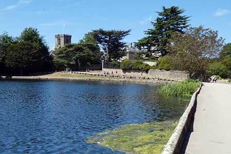
The walk starts from parking beside St Michael with St Mary church in Melbourne (grid ref. SK389250). After parking, walk down the lane to the left of the church to reach The Pool. You are now following the Cross Britain way. Follow the path around the edge of the lake, cross a small bridge and follow the clear track (Pool Road) that bends left. Continue along the track until it bends right. Just after the bends veer half-left across grass keeping the avenue of trees to your left. Head for the far right-hand corner of the field. Pass to the right of a group of buildings and continue straight across a field to exit onto a lane (grid ref. SK400241).
Cross to the path opposite. The clear path skirts trees on your right and continues passing between trees to exit onto Squirrel Lane (grid ref. SK404236). Cross the lane to the path opposite which rises through woodland to join a lane. Bear right up the lane and continue to pass St Mary and St Hardulph Priory Church which occupies the summit area of Breedon Hill. As you might expect the views are extensive. Continue ahead through a wall gap and veer left to join a path descending into the village of Breedon on the Hill. Keep ahead at all junctions and exit onto Hollow Road. Turn right and almost immediately left along Melbourne Road. Pass the Hollybush Inn and keep right with the village green on your left.
Reaching the third set of bollards in the middle of the road (grid ref. SK402228), turn right onto a track which runs beside a stream on your left. The track continues beside the stream and then turns right between hedges. The track then leads into a field. The path runs along the left-hand edge of a golf course. The path is marked with yellow waymarks and leads to Park Pale. Turn right and after 50 metres turn left across a field. The path runs to the left of a pole and passes through two strips of woodland, crossing a footbridge in the second belt of trees.
Exit the trees, cross a field to the far side (grid ref. SK389237) and turn right along a clear track. When the track bends left continue ahead through a hedge into a field. The path continues initially along the right-hand field edge past Quarry Wood. The path then heads straight across the next field before veering slight left across the next field to exit onto Pool Road (used at the start of the walk). Turn left, and then pass through a gate on the left to join a path running along the south side of The Pool. The path soon leaves the lakeside and heads diagonally across a field to pass to the left of Pool Farm. Turn left along the farm's access drive and after 140 metres, turn right off the drive to follow a track which leads between house to the B587. Turn right and after 250 metres turn right onto a signed footpath. Keep ahead at all junctions and exit onto Penn Lane. Turn right and return to the start by Melbourne Church.
Other walks nearby
| Walk 1608 | Calke Abbey & Robin Wood from Ticknall | easy/mod | 8.0 miles |
| Walk 2234 | Belton, Osgathorpe, Worthington & Wilson | moderate | 13.8 miles |
| Walk 2080 | Belton, Osgathorpe, & Worthington | easy/mod | 10.3 miles |
| Walk 1487 | Blackbrook Reservoir & Nanpantan | moderate | 12.0 miles |
| Walk 1540 | Nanpantan Reservoir, Wood Brook and Buck Hill | easy | 2.5 miles |
| Walk 2941 | Out Wood & Beacon Hill from Loughborough | easy/mod | 6.8 miles |
| Walk 1592 | Thornton Reservoir | easy | 2.5 miles |
| Walk 2315 | Old John & Beacon Hill | easy/mod | 8.8 miles |
| Walk 2175 | Bradgate Park from Newtown Linford | easy | 4.8 miles |
| Walk 2187 | Bradgate Country Park from Hallgates | easy | 3.4 miles |
Recommended Books & eBooks
Walking in Derbyshire
 Walking guidebook to 60 circular day walks in Derbyshire and the Peak District. Includes the Derwent, Wye and Trent river valleys, near Derby, Matlock, Glossop, Bakewell and Ripley. Routes range from easy to moderate and are between 4 and 14km (2 to 10 miles). Walks focus on places of interest, from Stone Age forts to castles to grand estates.
More information
Walking in the Peak District - White Peak East
 Guidebook describing 42 half-day and day walks in the limestone landscapes of Derbyshire's White Peak, part of the Peak District National Park. One of two volumes, this book covers the east of the region, with potential bases including Bakewell, Eyam, Castleton, Birchover, Matlock and Wirksworth.
More information
Messaging & Social Media
Message Walking Britain and follow the latest news.

Mountain Weather
Stay safe on the mountains with detailed weather forecasts - for iOS devices or for Android devices.