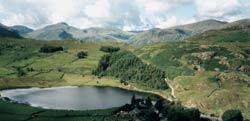
Standing Crag & Dock Tarn from Watendlath
Lake District Walk
Nat Park - Lake District - Lake District Central Fells
County/Area - Cumbria
Author - Mike Bexley
Length - 7.0 miles / 11.4 km Ascent - 1600 feet / 485 metres
Time - 5 hours 10 minutes Grade - moderate
Maps 

| Ordnance Survey Explorer OL4 | Sheet Map | 1:25k | BUY |
| Anquet OS Explorer OL4 | Digital Map | 1:25k | BUY |
| Ordnance Survey Landranger 90 | Sheet Map | 1:50k | BUY |
| Anquet OS Landranger 90 | Digital Map | 1:50k | BUY |
Walk Route Description
Click image to see photo description.
This Lake District walk from Watendlath includes some of the open fell that forms the backbone of the Lake District. It offers good views although it can be wet underfoot especially after heavy rain and should not be attempted without good boots, waterproof clothing, map and compass.
The walk starts from the lovely, peaceful National Trust Hamlet of Watendlath (grid ref NY276163) situated at the end of a single track lane, off the B5289 Keswick to Borrowdale road. At first proceed in an easterly direction from the car park climbing part way up the hill. take the first path on the right, keeping to the left hand side of the wall. The footpath begins well but can be extremely wet by the time you reach the remote Blea Tarn (grid ref 290143). Meaning 'Blue Tarn' this sizeable stretch of water is flanked to the south-west by the cliffs of Low Saddle.
Follow the wet footpath to the left of the tarn crossing the stile at the boundary fence. Turn right to follow the path that climbs steeply through a gully to the left of the imposing Standing Crag. This path (not indicated on all maps) swings right, after the gully near the top, to meet the boundary fence behind Standing Crag.
Pick up and follow the well-worn path with the fence on you right until you reach the corner of the fence - the fence turns sharp right here. To continue cross over the stile on you right to walk to High Saddle then pick your way along the feint paths over Coldbarrow Fell to Lord's How (grid ref 283139).
It is good idea on this long approach across the heather clad fell to take a compass bearing of Dock Tarn if visible. Go to the far left side of Dock Tarn where you will pick up the path that has come up from Stonethwaite . Continue on this path, which drops down to Watendlath Tarn. Then it is over the pack horse bridge to your start.
Other walks nearby
| Walk 1693 | Grange & Watendlath from Rosthwaite | easy/mod | 7.6 miles |
| Walk 1444 | Great Gable (Borrowdale route) | hard | 12.0 miles |
| Walk 1268 | Cat Bells & High Spy | moderate | 8.0 miles |
| Walk 3328 | Eagle Crag & Seargeant's Crag from Stonethwaite | moderate | 7.0 miles |
| Walk 3133 | Ullscarf and Watendlath from Stonethwaite | mod/hard | 10.0 miles |
| Walk 3132 | High Tove & Blea Tarn | moderate | 7.6 miles |
| Walk 1108 | Ashness Bridge & Grange Fell | moderate | 9.0 miles |
| Walk 1175 | Combe Gill Circuit | moderate | 5.5 miles |
| Walk 1247 | Helvellyn & Raise from Swirls | mod/hard | 7.0 miles |
| Walk 2025 | Helvellyn & Wythburn from Swirls | mod/hard | 8.5 miles |
Recommended Books & eBooks
Walking the Lake District Fells - Langdale
 Part of the Walking the Lake District Fells series, this guidebook covers a wide range of routes to 25 Lakeland summits that can be climbed from the Great Langdale valley, Ambleside and Grasmere, with highlights including Scafell Pike, Bowfell, the Langdale Pikes and Helm Crag (the Lion and the Lamb). Includes suggestions for longer ridge routes.
More information
Outdoor Adventures with Children - Lake District
 Guidebook to 40 outdoor adventures in the Lake District with children under 12, including walking, cycling, orienteering, paddling, boating, hostelling and more. Graded activities for varying age ranges or for families with children of different ages.
More information
Messaging & Social Media
Message Walking Britain and follow the latest news.

Mountain Weather
Stay safe on the mountains with detailed weather forecasts - for iOS devices or for Android devices.