Rivington Pike Walk
Walk 2532 - Route Maps
Route Map
Digital Maps - Copyright © 2011-2024. All rights reserved.
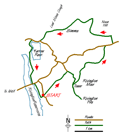
Sketch Map
Suggested Maps 

| Ordnance Survey Explorer 287 | Sheet Map | 1:25k | BUY |
| Anquet OS Explorer 287 | Digital Map | 1:25k | BUY |
| Ordnance Survey Landranger 109 | Sheet Map | 1:50k | BUY |
| Anquet OS Landranger 109 | Digital Map | 1:50k | BUY |
It is recommended you take a map. The preferred scale is 1:25k.
Start Point Details
Ordnance Survey Grid Ref SD628139
Latitude 53.62031 Longitude -2.563864
Postcode BL6 7RZ
what3words start tops.stapled.shun
Walk description may contain detailed information on the start point for this walk.
Further Information
Lancashire
Lancashire offers many walking opportunities with a number of areas of high ground. The highest point is Gragareth (near Whernside) at 627 metres. The rivers drain west from the Pennines. The coast is backed by a coastal plain. Excellent areas for walking include Arnside and Silverdale National Landscape, Beacon Fell Country Park and the Forest of Bowland AONB, which includes Pendle Hill. Further south are the West Pennine Moors and the Forest of Rossendale.
Walk grading - Learn how each walk is assessed and select a walk to suit your ability and experience by going to Walk Grading Details.
Messaging & Social Media
Message Walking Britain and follow the latest news.

Mountain Weather
Stay safe on the mountains with detailed weather forecasts - for iOS devices or for Android devices.