West Highland Way Experience
Loch Lomond and Trossachs Walk
Nat Park - Loch Lomond and Trossachs
County/Area - East Dunbartonshire & Stirling & Argyll and Bute
Author - Mike Bexley
Length - 95.0 miles / 154.4 km
Ascent - nominal or unknown
Time - 47 hours 30 minutes Grade - moderate
Maps 

| Ordnance Survey Explorer 348 | Sheet Map | 1:25k | BUY |
| Anquet OS Explorer 348 | Digital Map | 1:25k | BUY |
| Ordnance Survey Explorer OL39 | Sheet Map | 1:25k | BUY |
| Anquet OS Explorer OL39 | Digital Map | 1:25k | BUY |
| Ordnance Survey Explorer 377 | Sheet Map | 1:25k | BUY |
| Anquet OS Explorer 377 | Digital Map | 1:25k | BUY |
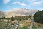
Walk Route Description
Click image to see photo description.
This is the second time I have walked the West Highland Way in Scotland. The distances each day and the overnight stops were in line with my last walk. There are some very good web sites and many books on the West Highland Way so this account aims to supplement current available information with details of the terrain and walking conditions together with some tips offered with the benefit of experience. Hopefully this diary will tempt others to undertake this wonderful walk.
Accompanied by three friends, I completed the walk in five days with over twenty miles covered on some days. Bed & Breakfast accommodation was used for overnight stops and the weather was excellent with sun and high temperatures every day. I carried all my kit, which with the inclusion of changes of clothing, waterproofs, 'just in case clothing' and extra drink, weighed 28 lbs (12.7 kilos). With hindsight, I would recommend the services that pick your bag up in the morning and leave it at your destination at night leaving you just a light daypack to carry.
Day 1 - Milngavie to Balmaha 19 miles - 31 km
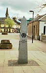 The walk starts in the Milngavie shopping centre, there is an inscribed column for your first photographs (grid ref NS555745). If you want a group photograph then there are plenty of willing people around who are used to such a request. I found throughout the walk that the local people were always interested and friendly even at road junctions the horns would sound.
Following the way markers, I left the shops and commercial properties. The Way is so well signed throughout that there is no need to refer to the map at any time but the WHW Official map does add interest.
This was a fairly easy day, marred at first by a diversion down the road to Drymen due to forestry work in Garadhban Forest. Later on a further diversion to the road again due to the closure of Conic Hill and the path past it was due to lambing taking place on the hills! This annual closure is worth noting. Balmaha situated on the shores of Loch Lomond has many B&B's and a couple of pubs. A good pub meal can be obtained in one of them.
Day 2 - Balmaha to Inverarnan- 19.75 miles - 32 km
 This was a much harder day and not to be underestimated. The footpath leaves Balmaha leading at first to climb steeply away from Loch Lomond for a superb view. It then returns down to the shoreline and lanes for easy walking passing the bar entrance to the Rowardennan Hotel!
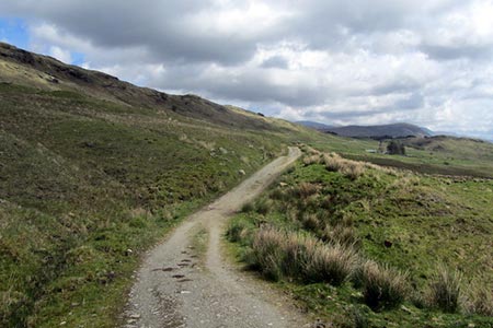
The pleasant walking continues for some miles along pretty forest roads before developing into a very rough and at times narrow path. Although the distance is measured at less than 20 miles (32 km), the distance must be greater due to the many detours around trees and their roots.
The path is constantly climbing up and down from the Loch. The next sign of civilisation is the Inversnaid Hotel. After I had passed the much photographed waterfalls, it was down some steps to a large car and coach park serving the Hotel. I did feel overdressed amongst these tourists. There is also a passenger ferry across the Loch from this point.
 Joining the path again I soon realised the path prior to the Hotel was easy compared to this. The going was very hard. In one place a ladder had been fixed to aid the climb over a boulder. There was the odd rest from the toil and this photograph of Stob nan Eighrach was taken from part of the forest that had been felled.
From leaving Balmaha the constant views across Loch Lomond were worth all the effort and there were many tempting stopping places to rest. My long day ended at the river bridge at Inverarnan.
Day 3 - Inverarnan to Inveroran - 21 miles - 33.5 km
Throughout the walk, during day and in the pub at night, I was meeting other people with the same goal. Experiences were relived and friendships made. In the early stages I heard some people had returned home due to lack of accommodation. It is worth noting that our overnight accommodation had been booked seven months in advance - obviously not too early.
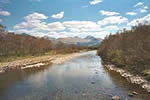
After yesterday, the walking was easier and with the odd exception fairly level. At first the path goes through Glen Falloch sharing the glen with the noisy A82 road.
 Crossing under this road with the rucksack was a dirty knee job. Taxi firms had placed their adverts and phone numbers here stating their willingness to collect you at any place on the walk.
The rising ground ahead was very wet and eroded until I reached the woods near Crianlarich with the path improving to provide a lovely stroll through the woods. Stopping at the viewpoint magnificent Glen Dochart is revealed with its Glenbruar Viaduct - the track my train would use when I returned to Milngavie. The backdrop was the mass of Ben More.
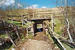
 The path led me out of the woods under another railway then over the A82 road to a bridge over the River Fillan.
A lane took me past the farm buildings and information board on St Fillan, an Irish monk who preached in this area, then a further crossing of the A82 to reach the outskirts of Tyndrum.
Once again I had to cross this road before climbing up a lane to cross over the railway. The Way was now an old military road. Hard on your feet, the start of many miles on these rough, stony roads. It is important that footwear has a sufficient cushion in the sole to withstand these stones.
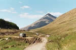 I was accompanied through this beautiful valley by the Fort William to Glasgow railway line. At first walking towards the impressive Beinn Dorain (1074 metres) then skirting to the left of its steep flanks, to arrive at the Bridge of Orchy Railway Station.
Crossing the A82 again, I realised I would not see this road again until reaching Kinghouse, near Glen Coe.
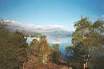
Ahead of me was a steep climb up and over Mam Carraigh, with another breathtaking view, this time of Loch Tulla and Rannoch Moor, a fitting end to wonderful day of easy walking.
Day 4 - Inveroran to Kinlochleven - 18.5 miles - 29.5 km
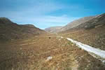
The day's walk started on a unclassified road and continued on wide stony paths that characterise the West Highland Way. This time the views on the left were of the wild, interesting Rannoch Moor and on the right the snow clad Stob Ghabhar and other mountains.
 During this walk I wore a wide brimmed hat. Brought to keep the rain off my glasses but I found its benefits in the sun. It kept its rays off my neck and by drenching it in water it cooled me down.
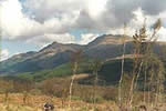
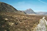
This must rate as the loneliest part of the walk and I enjoyed every mile. I also knew that when I passed the memorial to Peter Fleming, brother of the James Bond story writer Ian, that I would have my first sighting of Stob Dearg of Buachaille Etive Mor. This mountain that guards the Pass of Glencoe, dominates the area and will do so for the next few miles.
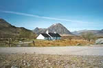 The Way continues towards the mountain, bearing left at Blackrock Cottage with Buachaille in the background to cross the A82 and pass the Kinghouse Hotel.
Once again I was on an old military road climbing slightly to give spectacular views of Buachaille and the start of Glencoe Pass. Then the path dropped down to run alongside the A82 prior to escaping steeply away from the road. The next time I would see this road would be at the finish. This steep climb has the strange name of Devil's Staircase.
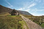
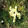 Stopping at the top for a last look behind me, the rough Old Military Road proceeded down towards Kinlochleven. Here the views were of Blackwater Reservoir. Built in the early 1900's to provide water to drive the electric turbines at the aluminium smelting plant at Kinlochleven. The smelting plant has since closed but the turbines provide power for the National Grid. The ugly pipes were revealed to me as I dropped into Kinlochleven and later I passed the water rushing into the River Leven after it had done its work. Throughout the walk in the dark shady areas there were clumps of Primroses.
Day 5 - Kinlochleven to Fort William - 14.25 miles - 23 km
 My last day. Once again it was a military road that I joined, climbing rapidly through woods away from Kinlochleven. In the distance was the Pap of Glencoe and in the foreground Loch Leven.
Then I was in the large, bleak Lairigmor Glen, with its own tumbling river. Surrounded by the bare slopes of mountains on three sides. Although I could see the path ahead for miles, I puzzled which low point I would use to leave this glen.
 I was amazed to find the ruins of two dwellings in this valley - thought to be the residence for families looking after cattle that were driven up here in the summer months.
Leaving the valley the path plunged into the forest, descending very slowly to reward me with my first sighting of Scotland's - and Britain's - highest mountain, Ben Nevis (this photograph was taken later).
 A lot of the forest had been felled and it was in that ugly state of broken branches and piled logs.
The path ended up on the road. All that remained was the anticlimax of walking along the road to the A82 roundabout in Fort William.
The next day was the classic train trip back to Milngavie during which you are able in part to relive many of the sights you have savoured during the walk.
THE END
Additional Maps required to those shown below
| Ordnance Survey Explorer 384 | Sheet Map | 1:25k | BUY MAP |
| Anquet OS Explorer 384 | Digital Map | 1:25k | BUY MAP |
| Ordnance Survey Explorer 392 | Sheet Map | 1:25k | BUY MAP |
| Anquet OS Explorer 392 | Digital Map | 1:25k | BUY MAP |
Other walks nearby
| Walk 1492 | WHW - Day 2 - Dryden to Rowardennan | moderate | 15.0 miles |
| Walk 2439 | Forth & Clyde Canal & Antonine Wall | easy | 6.0 miles |
| Walk 2347 | Duncryne from Gartocharn | easy | 2.0 miles |
| Walk 2659 | Conic Hill | easy/mod | 4.0 miles |
| Walk 1296 | Beinn Eich & Doune Hill | mod/hard | 8.0 miles |
| Walk 3009 | Ben Lomond | mod/hard | 7.5 miles |
| Walk 1493 | WHW - Day 3 - Rowardennan to Inverarnan | moderate | 14.0 miles |
| Walk 2413 | Ben Venue from Loch Achray | moderate | 8.2 miles |
| Walk 2309 | Ben A'an from Loch Achray | easy/mod | 2.5 miles |
| Walk 3647 | Callander, Samson's Stone & Coilhallan Wood | easy | 4.7 miles |
Recommended Books & eBooks
West Highland Way Map Booklet
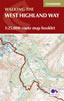 This compact booklet of maps shows the full route of the 95 mile West Highland Way Scottish Long Distance Route, via Loch Lomond and Rannoch Moor. This booklet is included with the Cicerone guidebook to the trail, and shows the full route on Ordnance Survey 1:25,000 maps.
More information
Walking Loch Lomond and the Trossachs
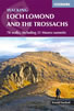 A guide to walking and scrambling routes in the beautiful Loch Lomond and the Trossachs National Park. Over 70 graded low-level, mid-level and mountain walks taking in hills, glens and picturesque woodland, as well as all of the region's Munro summits. Highlights include Ben Lui, Ben Lomond, the Cobbler and the Arrochar Alps.
More information
Messaging & Social Media
Message Walking Britain and follow the latest news.

Mountain Weather
Stay safe on the mountains with detailed weather forecasts - for iOS devices or for Android devices.