Carnedd Dafydd & Pen yr Ole Wen from Bethesda
Snowdonia/Eryri Walk
Nat Park - Snowdonia - Western Carneddau
County/Area - Gwynedd & Conwy
Author - Nick O'Brien
Length - 8.0 miles / 13 km Ascent - 3370 feet / 1021 metres
Time - 7 hours 20 minutes Grade - mod/hard
Maps 

| Ordnance Survey Explorer OL17 | Sheet Map | 1:25k | BUY |
| Anquet OS Explorer OL17 | Digital Map | 1:25k | BUY |
| Ordnance Survey Landranger 115 | Sheet Map | 1:50k | BUY |
| Anquet OS Landranger 115 | Digital Map | 1:50k | BUY |
Walk Route Description
Click image to see photo description.
Although the Carneddau do not have the honour of containing the highest mountain in England and Wales they do have the most extensive area over three thousand feet. This walk, which uses less frequented routes, visits two of the major peaks in this high mountain area. It also avoid the steep climb onto Pen yr Ole Wen from Ogwen Cottage yet still provides superb mountain scenery and high ground.
Like any mountain walk care needs to be exercised if taking this route. The paths followed by this walk are not well walked and hence route finding could be very difficult in poor visibility. It might be argued that this walk should be saved for a fine day as the views are superb. In addition there are some substantial crags close by and errors in navigation could prove fatal. Do take care.
This Snowdonia (Eryri) walk starts from the lay-by (Grid ref. SH627654) above the Ogwen Bank Caravan Site on the west side of the A5 about a mile south of Bethesda. This caravan site is clearly signposted in the vicinity. Almost opposite the lay-by is a gate into the woodland. Here there is a path that climbs steadily zigzagging up the first section. As you feel the path coming back around, turn right and head south. The edge of the woodland is soon reached and the views across Nant Francon to Mynydd Perfedd, with the Atlantic Slab, and beyond to Y Garn unfold.
Keeping to the higher ground, Carnedd Dafydd comes into view. There are three distinct streams coming down the mountainside. Head for the stream to the right - Afon Berthen - taking care not to sacrifice any height you have already gained. Following this stream will lead you into a shallow valley to the left of Foelgraig. On your right you will see a wall. Take careful note as this is your route down.
The going steepens and the effort is rewarded as you gain the summit of Carnedd Dafydd. From here there are spectacular views over to the Glyders and Tryfan; Carnedd LLewellyn; and north to the whole of Anglesey. The next section will be much busier and you can expect to encounter other walkers as you follow the broad, clear path southwest to Pen yr Ole Wen. This is an excellent ridge walk with the view left down into Cwm Loer especially worthy of note.
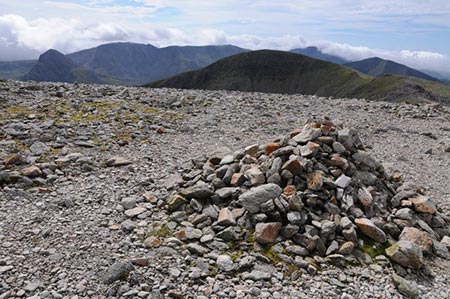
Half way along the ridge you pass a large cairn or pile of stones. This is Carnedd Fach and should not be confused as being the summit of Pen yr Ole Wen, which is reached after an easy short climb. From the summit go north to pick up an intermittent path that follows the top of the crags named Braich Ty Du. In places these crags are precipitous so take care. After approximately half a mile you will reach the wall that you noted on the ascent. Keeping this wall on your left descend steadily to reach a stile above the A5. Crossing this you encounter a few more stiles as you skirt the woodland down to the A5 at Ty'n-y-maes. Turn right and follow this main road to reach the start in a mile.
Other walks nearby
| Walk 2115 | Yr Elen, Carnedd Llewellyn & Carnedd Dafydd | hard | 9.5 miles |
| Walk 3051 | Yr Elen from Gerlan | hard | 6.5 miles |
| Walk 3052 | Yr Elen & Carnedd Dafydd from Gerlan | hard | 9.0 miles |
| Walk 1074 | The Glyders Traverse | very hard | 12.0 miles |
| Walk 2833 | Moel Faban, Gyrn & Moel Wnion from Rachub | easy/mod | 5.0 miles |
| Walk 1315 | Drosgl and Gyrn Wigau from Rachub | moderate | 7.5 miles |
| Walk 1453 | Elidir Fawr, Mynydd Perfedd & Marchlyn Mawr reservoir | moderate | 6.0 miles |
| Walk 1088 | Glyder Ridge traverse | hard | 5.5 miles |
| Walk 1186 | Y Garn | mod/hard | 4.5 miles |
| Walk 3019 | Y Garn & Carnedd y Filiast Ogwen Cottage | hard | 8.5 miles |
Recommended Books & eBooks
Snowdonia: 30 Low-level and easy walks - North
 Guidebook describing 30 walks in Snowdonia, Wales. Routes are mostly low level and on clear paths and showcase the region's beautiful scenery and rich history and culture. Part of a 2-volume set, this northern volume includes the Snowdon area, the Ogwen and Conwy Valleys, Betws-y-Coed, Beddgelert, Ffestiniog and the coast.
More information
Mountain Walking in Snowdonia
 Guidebook to 40 of Snowdonia's best day walks, with routes up Snowdon and Tryfan, including the Snowdon Horseshoe, Cadair Idris, Y Garn and The Rhinogs. The routes range from Grade 1 scrambles like Crib Goch or Bristly Ridge, to riverside and forest walks. Includes details of a 2-day traverse of all 15 of Snowdonia's 3000ft peaks.
More information
Messaging & Social Media
Message Walking Britain and follow the latest news.

Mountain Weather
Stay safe on the mountains with detailed weather forecasts - for iOS devices or for Android devices.