Mynydd Eilian & Fresh Water Bay from Llaneilian
Coastal Walk + Hill Walk
County/Area - Isle of Anglesey
Author - Lou Johnson
Length - 6.0 miles / 9.8 km Ascent - 1000 feet / 303 metres
Time - 4 hours 0 minutes Grade - moderate
Maps 

| Ordnance Survey Explorer 263 | Sheet Map | 1:25k | BUY |
| Anquet OS Explorer 263 | Digital Map | 1:25k | BUY |
Walk Route Description
Click image to see photo description.
Starting from Llaneilian this circular walk explores the countryside and coast. The route starts by following a section of the Isle of Anglesey Coast Path before turning inland to pass the church at Plas Eilian. The walk continues across countryside before a short ascent to the summit of Mynydd Eilian from where the view includes some of the walk. The concluding section of the route leads to the coast where the coast path returns to Llaneilian with a diversion to the Point Lynas lighthouse and the rocky headland.
The walk starts from the car park in Llaneilian (grid ref. SH475929). After parking exit the car park and turn right to Porth Eilian. Reaching the seafront turn left through a gate to join the coast path. Following the cliff top you soon get a view across the bay to Point Lynas and its lighthouse. Continue ahead passing through several gates to reach the next inlet. After passing through a gate descend grassy steps and turn left at a way past (grid ref. SH470932) and head uphill away from the coast. The path leads to Plas Eilian with its church on your left.
Reaching a lane turn right and continue for 300 metres. Turn left just past Llaneilian W I Hall onto a clear track with adjacent fingerpost. Follow the track towards Henblast. Just before the buildings turn right through a kissing gate, turn right uphill and just past the buildings turn left and continue across fields to a ladder stile and a lane (grid ref. SH470923). Turn right and continue to the village of Pengorffwysfa. Turn left at the T-junction and then left again up a lane signed unsuitable for long vehicles. The lane climbs steadily to a junction near a bench. Turn right uphill and take the first signed footpath on the left. The path climbs to the summit of Mynydd Eilian (177 m.) with an OS trig column marking the highest point. Mynydd Eilian is one the highest hills on the Isle of Anglesey.
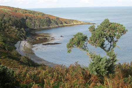
After enjoying the view which includes Snowdonia return down the path to a wall corner on the right and turn right off the main path across a field. The path slants down the hillside and exits at a kissing gate. Turn right up the lane enjoying view to the coast on your left. When the lane forks, keep right, and continue to climb. Reaching the summit of the road you have a view ahead to the mountains of Snowdonia. Follow the lane down into a shallow valley and after 160 metres take the next signed path on the left. The path follows a wall on your right down to the coast path (grid ref. SH486917). Follow the coast path north to reach the sandy cove of Porth y Corwgl (grid ref. SH482927). After the cove, the path turns right and briefly follows the clifftops before turning left alongside a wall (on your left) to a road (grid ref. SH479930).
Turn right and continue to Point Lynas lighthouse. It is worth exploring beyond the lighthouse using a network of paths around the rocky headland. To return to the start of the walk, follow the road away from the lighthouse back past Porth Eilian and up to the car park.
Other walks nearby
| Walk 2933 | Dinas Gynfor from Cemaes Bay, Anglesey | easy | 4.0 miles |
| Walk 3580 | Carmel Head & the Skerries from near Cemlyn Bay | easy | 4.5 miles |
| Walk 3040 | Church Bay & Mynydd y Garn from Swtan | easy/mod | 6.0 miles |
| Walk 1702 | Rhoscolyn Headland | easy | 5.5 miles |
| Walk 3020 | Aber Falls, Foel-fras & Drum | mod/hard | 9.0 miles |
| Walk 3021 | Northern Carneddau | mod/hard | 12.0 miles |
| Walk 3039 | Holyhead Mountain | easy/mod | 4.5 miles |
| Walk 1315 | Drosgl and Gyrn Wigau from Rachub | moderate | 7.5 miles |
| Walk 2833 | Moel Faban, Gyrn & Moel Wnion from Rachub | easy/mod | 5.0 miles |
| Walk 2346 | Yr Orsedd ridge from near Bont Newydd | moderate | 4.8 miles |
Recommended Books & eBooks
No suggestions for this area.Messaging & Social Media
Message Walking Britain and follow the latest news.

Mountain Weather
Stay safe on the mountains with detailed weather forecasts - for iOS devices or for Android devices.